

Swedes, Germans and Dutch people can be seen on the jetties of Gran Canaria, as well as English and Polish people. Lots of sailing boats, with motor yachts in between. An aluminium ketch from Poland had the longest journey. It's almost like the Baltic Sea. But only almost. Because the splendour of the bougain villea and hibiscus flowers around the harbour wouldn't stand a chance in northern climes. The deep blue of the sea doesn't fit either.
Twelve months of summer on Gran Canaria
And then the temperature: 22 degrees in December on Gran Canaria - you can only dream of that in Travemünde. Despite the familiar home harbours on the sterns: Germany is 2,000 nautical miles away. This is not Port Olpenitz, but Puerto de Mogán, in the south of Gran Canaria. The fact that so many boats from northern Europe have nevertheless found their way here - the smaller ones probably more as deck cargo or on trailers - is of course due to the climate: twelve months of summer, unbeatable. And when it comes to dream destinations, the Canary Islands are still a realistic destination. In any case, skippers with wanderlust are well catered for there, and not just from a nautical point of view.
More on the topic:
Gran Canaria has the best climate in the world
The largest and most populous of the Canary Islands in terms of area is Tenerife, the longest is Fuerteventura. Gran Canaria is at the forefront when it comes to climate: there are around forty different zones, from the exposed high altitudes to the lowlands. barrancos, deep gorges - a continent in miniature with rich native flora and fauna, from the Osorio shrew to the Canary Island pine, which even survives fires.
The north is the green side of Gran Canaria. It faces the trade wind, which usually blows constantly from the north-east and brings with it pleasant temperatures and humidity. The laurel forests at higher altitudes, often shrouded in mist, are evidence of this. According to studies, the capital Las Palmas, which lies in the north-east, has the best climate in the world. 380,000 people live here - almost twice as many as in the second largest city in the Canary Islands, Santa Cruz on Tenerife.
First port of call: Las Palmas
As far as sea transport is concerned, Las Palmas on Gran Canaria is the first port of call in the archipelago. From here, there are not only weekly ferries to the Spanish mainland, but also to the neighbouring islands. There are also around one million cruise passengers every year. The airport is connected via the GC 1 coastal motorway and can be reached in just under half an hour. In terms of flair, Europe and Central America meet in Las Palmas, a modern metropolis and a labyrinthine old town. One example of the modern city is the Poema del Mar seawater aquarium near the fishing harbour, which opened in 2017. It is the largest in Europe. The historic Las Palmas can be found in the shady alleyways of the Vegueta, the oldest neighbourhood: the Plaza de Santa Ana flanked by palm trees. At its front rises the cathedral of the same name, the construction of which began in 1497. With the popular Playa de las Canteras, the city also has its own local beach.
Gran Canaria - shaped by volcanoes
Gran Canaria's volcanic past is visible everywhere on the island, from the rugged coastline to the 1956 metre high Morro de la Agujereada. Roque Nublo is one of the island's landmarks: the 65 metre high basalt rock is the vent of a former volcano. While the softer rock of the cone was eroded by wind and weather, the "foggy rock" remained standing. But the solidified shapes are deceptive: It is still bubbling under the crust. The monumental cliffs in the north-west of the island are a prime example of the enormous fault lines that the forces lurking there are capable of. In the Tamadaba Nature Park, it stretches from Agaete to Mirador del Balcón. The traces of Gran Canaria's indigenous inhabitants, on the other hand, have almost disappeared. However, the archaeological interpretation centre La Fortaleza provides an exciting insight into the lives of these people.
The hot south of Gran Canaria
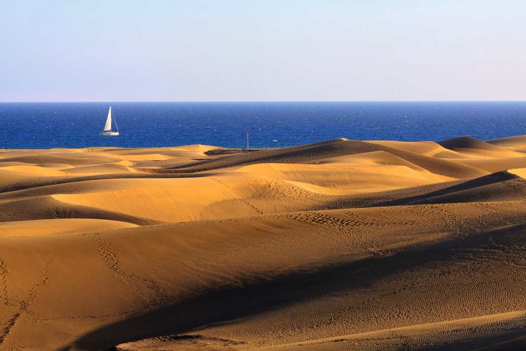
The south of Gran Canaria, El Sur, is virtually unaffected by the rainfall in the north. The mountainous interior keeps the moisture out like a wall. This makes the landscape all the drier. The calima exacerbates the situation. Although the desert wind only blows from the east, straight out of the Sahara, in special weather conditions, it not only brings temperatures of up to 50 degrees Celsius, but also covers the sky behind a pale veil of dust. As far as tourism is concerned, however, the sheltered location has proved to be a decisive advantage. The best proof of this are the hotel complexes along the sandy beaches of Bahía Feliz, San Agustín and Playa del Inglés.
But it can also be much quieter - and no less inviting: to the west of the famous dunes and the striking Maspalomas lighthouse, the coast becomes rougher, but in the deeply incised valleys of the barrancos and cañadas there are other places that leave nothing to be desired, especially for visitors on their own keel. Where fishermen used to keep to themselves and pull their boats directly onto the beach in open bays, yachts from all over the world are now moored on fixed jetties behind secure stone piers.
The harbours of Gran Canaria
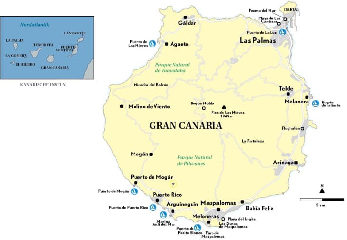
We present the most important and most beautiful harbours for sailors:

Las Palmas
The Las Palmas marina in the south of Puerto de la Luz is the largest in the Canary Islands: With more than 1,300 berths (even fifty-metre yachts can be accommodated here) and a range of services for every conceivable service, it is not surprising that it also plays an important role in stage plans for Atlantic crossings on the barefoot route. marina.palmasport.es
This also applies to the harbour in general: Las Palmas, for example, is the traditional starting point for the Atlantic Rally for Cruisers (ARC), whose field of cruises, regatta yachts and multihulls gathers here every year before heading over to St. Lucia with the north-east trade winds, where most of the yachts arrive in mid-December. This year, the start will take place in Las Palmas on 23 November.
However, the last "celebrity guest" in the harbour had a different destination: shortly after the start of the Vendée Globe last November, Hungarian participant Szabolcs Weöres had to visit Las Palmas to repair storm damage to the rig of his Imoca "New Europe". He was able to carry out the work on a mooring buoy in front of the marina, as prescribed, without assistance before he was able to continue the race around the world.
Puerto Rico
With around 530 berths in two basins, Puerto Rico is the largest of five marinas on this stretch of coast, which is just twenty kilometres long. Guests are accommodated at Puerto Base in the eastern part of the harbour. The service on the jetty and ashore is comprehensive (grancanaria.com; search: haefen). The same applies to supplies on land: there is a supermarket at the harbour and the modern Mogan Mall shopping centre is just a ten-minute walk away. Puerto Rico is also the starting point for ferry trips and excursions along the coast, water sports activities and dolphin and whale safaris.
Pasito Blanco
In contrast, Pasito Blanco, the first harbour west of Maspalomas, has a sophisticated club atmosphere. Full service is also offered here, from electricity at the jetty to the boat filling station and the 70-tonne travel lift. 388 berths are available (grancanariablue. com/en/marinas). Deep-sea fishing is also very popular. Depending on the season, you can compete with bonito, barracuda, blue fin and even blue marlin.
Puerto de Mogán
Puerto de Mogán is the last town before the coast turns northwards, rises further and merges into the wild west of Gran Canaria. You will look in vain for towering hotels here, the charm of a fishing village has been preserved, even if holidaymakers also make out the more lucrative catch here. At first glance, you would never guess that the neighbourhood directly on the harbour with its rectangular alleyways and flower-bedecked façades dates back to the 1980s. But this style is true because the buildings have been adapted to the old neighbourhood, which is located next door on the slope of the barranco pulls up.
At the harbour, the first row belongs to the bars and restaurants, such as the Casito Mediterraneo. There are 246 berths in Puerto de Mogán, spread over the three floating jetties, the harbour wall and the inside of the piers. grancanariablue.com/en/marinas
However, the most beautiful spot is outside: passing the fishing harbour and stony beach, you come to the foot of the cliffs. A narrow, well-trodden path leads closely along the cliff to a natural terrace. There is a lot going on here, especially at sunset, with bottles of wine clinking to Caribbean beats. The silhouette of Pico del Teide on Tenerife rises darkly out of the ocean. You briefly catch a glimpse of the neighbouring island before turning your attention back to the sunset. But your thoughts continue. Past the low sun, they reach into the distance beyond the horizon, across the Atlantic - to new shores.
More harbours
Puerto de las Nieves in the north-west, Puerto de Taliarte in the east and Marina Anti del Mar in the south have not been explicitly labelled as they are not designed for guest yachtsmen or do not have any special attractions.
Nautical information Gran Canaria
The Canary Islands are located at a position of 28°30' N, 15°52' W in the eastern central Atlantic off the African coast. The shortest distance to the mainland is 100 kilometres (Fuerteventura), the longest around 420 kilometres (La Palma). The nearest Spanish mainland port of Cádiz, to which there are also ferry connections, including to Las Palmas on Gran Canaria, is around 1,000 kilometres (540 nautical miles) to the north-east.
The Canary Islands, which belong to Spain, comprise eleven islands, eight of which are inhabited. The largest and most populous is Tenerife, while the largest city is Las Palmas, which also has the most important harbour. The seabed around the islands drops steeply to a depth of several thousand metres.
Two traffic separation zones have been designated between Tenerife, Gran Canaria and Fuerteventura. The Spanish Maritime Rescue Service (Salvamento Marítimo) is responsible for the SAR area, while the Coast Guard (Servicio Marítimo de la Guardia Civil) is responsible for public order tasks.
Literature
Territory guide "Atlantic Islands" by A. Hammick, H. Keatinge, L. Lane Thornton. Comprehensive guide to the Azores, Madeira, Canary Islands and Cape Verde. With Bermuda. Imray, 7th ed. 2021; A4 format, hardcover; 61.20 euros. ISBN 978-1-78679-070-5. nvcharts.com
Sea charts NV Atlas ATL 3 "Atlantic Islands/Madeira - Canary Islands - Azores - Cape Verdes", stapled, A3 format (opened A2), 6 over-sailors, 13 area charts, 28 detailed charts, harbour plans, tide tables; 74.99 euros. nvcharts.com

