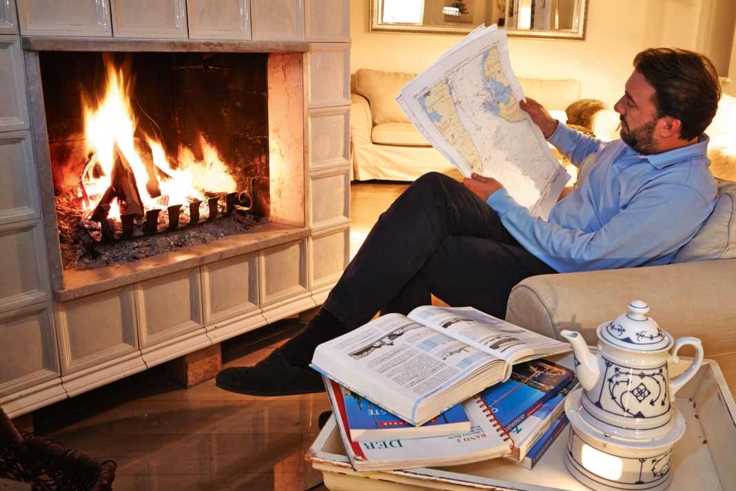


Which destination are we heading for on this year's summer cruise? You can't ask yourself this question soon enough. Especially as dreaming about cruising destinations increases anticipation and is simply fun. However, this question often doesn't come up on board, with nautical charts and a plotter within easy reach, but rather in conversation with friends, family or during a break at work. Then there may be a navigation app on your smartphone, but you can't see much on the small display. So off to a larger screen, but where can you find a nautical chart? Ideally quickly available and free of charge? There are several providers online, but the scope of services varies greatly.
Read also:
It is not always possible to create routes or even read off exact water depths in the programmes. What would be useless for navigation may, however, be sufficient for an initial overview. Especially as the functional scope of different providers can be combined. In fact, Google Maps can already provide good services if you already have a rough idea of a possible cruising destination. For example, a coastline, harbour town or an island that you have always wanted to sail to.
First impression via satellite images
Then a look at the satellite images from the Google Maps service can be enlightening. Which harbours are on the way, are there any anchorages to be discovered from the air? Anchorages can often be seen on satellite images and provide an initial indication of which spots are accessible for pleasure craft. Harbours and accessory shops, shipyards and general shopping facilities that are linked directly to the map or satellite image are also clearly visible on the images. Simple distance measurements are also possible. However, these are only very rough estimates without a nautical chart. There are other providers for assessing fairways and water depths.
Boatrouting.com, for example, can be used to plan trips along the German coast. The automatically generated route becomes more accurate if you enter your own boat data. However, this does not work with the draught. This makes it clear that the planning tool is aimed particularly at motorboats. However, Boatrouting also offers maps of German and Dutch inland waterways. Although OpenSeaMap does not provide area-wide depth information either, routes can also be created. In addition, the site works through additions from the mass of users. For example, special hardware can be used to plumb the depth on a cruise and add it to the maps. This is why there is also depth information in places. An overlay with weather data is also possible. Complete nautical charts can be found at C-Map. The German coast and Sweden can be viewed here. Denmark is not included. The site does not offer a route function.
However, the precise nautical charts can be used to explore an anchor bay, for example, which looked appealing on Google Maps. But that's already the fine tuning. Routes can be created with OpenSeaMap, Ocean.Guide or Boatrouting.
Navigation apps


Plan alternative ports
Then you can estimate how many days the planned trip will take. If a harbour is always to be visited at night, it naturally takes longer and more stops have to be planned. Including a night voyage on the outward journey increases the Etmal enormously and then leaves more time to explore the destination area. Depending on the preferences of the crew and the energy management on board, anchor stops can then be useful. Both when searching for suitable harbours and when virtually exploring anchorages, the following applies: a lot helps a lot.
The summer cruise is never long enough to visit all the destinations in the plan. However, you never know how the weather will actually develop later and alternative stops can be better selected in advance. Different weather conditions and wind directions should also be taken into account. Which harbour, which bay offers me protection in easterly winds? Which harbour should I avoid because it is unprotected against swell in one direction? Where can I get diesel, when is food likely to be scarce?
Another point in the planning is crew changes. If there is a crew change, this can simply be done by car. Nevertheless, the harbour chosen for this should be easily accessible. If only one crew member is joining you, it makes sense to choose a harbour with public transport connections. Google helps here with route planning by road and rail in conjunction with a nautical chart tool to view the conditions in the harbour.
The planning aids cannot replace route planning on paper or on a plotter. Nevertheless, the large overview is an advantage. The displays of navigation instruments are usually smaller, so it's easy to lose track or overlook details that only appear a few zoom levels down. With a prepared route plan, you already have the main challenges in view and can set the route point by point. Autorouting functions, in which only the start and destination are marked and all waypoints are set automatically, save a lot of time, but the user still has to keep a close eye on things. The course is often unnecessarily close to shallows or, on the contrary, stoically follows a fairway, although the water depth also allows a shortcut. It therefore makes sense to take a look at the settings. The boat data must be defined here.
Include navigational aspects in cruise planning
The right draught in particular is crucial for a safe routing result. Most apps do not take the weather into account in their route suggestions. Orca or Squid are exceptions here. If wind and waves and their changes throughout the day are not taken into account, the user has to think for themselves with the help of a weather app. Will a small diversions of a few miles perhaps get you to the shelter of a coast faster, so that a cross with fewer waves can be mastered more quickly and with fewer boat movements? Such very precise considerations can only be made a few days before the trip, but are essential to finalise the rough advance planning.
However, charting the course is quicker if you have familiarised yourself with the area beforehand and know where special care may be needed, such as in narrow fairways and traffic separation zones or where a harbour offers protection as an alternative stopover if the weather deteriorates at short notice.
Planning at home not only whets the appetite for the coming sailing season, but also increases safety through precise knowledge of the sailing area. Especially if you want to head for previously unknown destinations.
So, do you already know where you're going this summer?
Overview of map services for cruise planning
Boatrouting.com
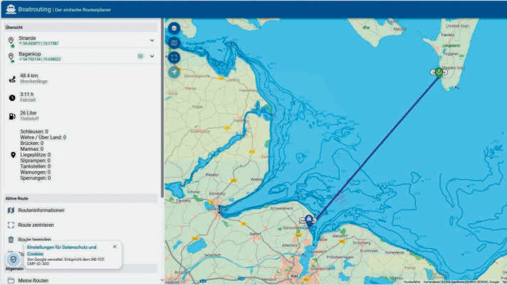
The operator calls itself "the simple route planner". You can set a starting point and destination and then create a route with a click. Nautical charts with depth contours and buoyage are available for the German North Sea and Baltic coasts. There are no nautical charts for Denmark and Sweden. Nevertheless, Boatrouting is sufficient to get a rough overview of distances. If the "My boat" section is personalised with ship data, the travel time and fuel consumption can be determined. This is only of limited use for sailing yachts, as it is best not to motor the entire route. The height above water can also be specified, but not the draught. However, there are charts for inland waterways in Germany and the Netherlands. In the free version, up to five routes can be created per day. More information: boatrouting.com
Route planning tool
Nautical charts for German coastal waters
Calculation of fuel consumption
No nautical chart for Denmark
No weather routing
Windy.com
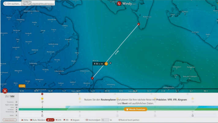
The app is used by many water sports enthusiasts on their smartphones. In addition to graphically very clearly presented weather forecasts, Windy can also do simple weather routing. Unfortunately, this only works well if a paid premium subscription is purchased. A route can then be created with any number of waypoints and the programme provides an overview of weather changes along the route. However, the user can only enter an average speed, so the routing does not take into account how fast your boat is in different conditions. In addition, the route must be set manually. The routing would of course be more accurate with polar data. However, the service does not offer nautical charts. Although distances can be measured and routes created, a different planning tool must be used for water depths and sea marks. More information: windy.com
Very clear weather forecast
Predictive rain radar
Simple weather routing
Routing with costs
No nautical charts
C-Map.com
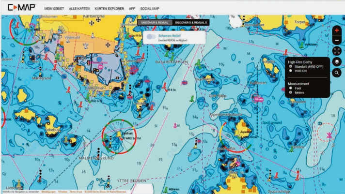
The site, which belongs to the Navico Group, offers nautical charts for many sea areas worldwide. Unfortunately, as is often the case, Danish waters are not included in the charts for licence reasons, but all other Baltic Sea countries are (with the exception of the Russian enclave of Kaliningrad). The site does not offer much more than an overview, as there is no distance measurement or route function. This somewhat limits its usefulness for cruise planning. However, in the second step of the planning process, C-Map is just right for checking whether the water depth and nature of the bottom in a bay, for example, make a good anchorage and how the approach is buoyed. The screenshot shows the sea area around Karlskrona in southern Sweden with numerous skerries and navigation marks. The map display is very clear and can certainly be helpful for cruise preparation in conjunction with other map services among other planning tools. More information: c-map.org
Nautical charts for the German coast
Nautical charts for the Swedish coast
Denmark not included
No route function
No weather routing
Ocean.guide
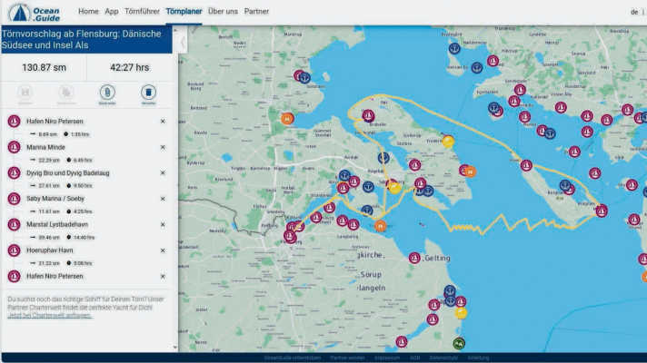
The site not only offers route planning tools, but also provides direct route suggestions. It is based on recommendations from the community and provides an overview of routes and sea marks, but no classic nautical charts with depth contours. Ocean.Guide should therefore only be used as a planning tool but not as a navigation tool. The service not only covers the Baltic Sea, but also offers routes along the French Atlantic coast and in the Mediterranean. In addition to the functionality as a trip planner, there is also a trip guide. This contains data compiled by users on harbours, anchorages and beaches. Wind data from Windy can also be displayed as an overlay in the free version. In the route planning, distances and average trip duration are broken down for the daily stages. This provides a quick overview. More information: ocean.guide
Route planning
Cruise suggestions
Weather data as overlay
Sea marks and traffic separation schemes
No depth information
OpenSeaMap.org
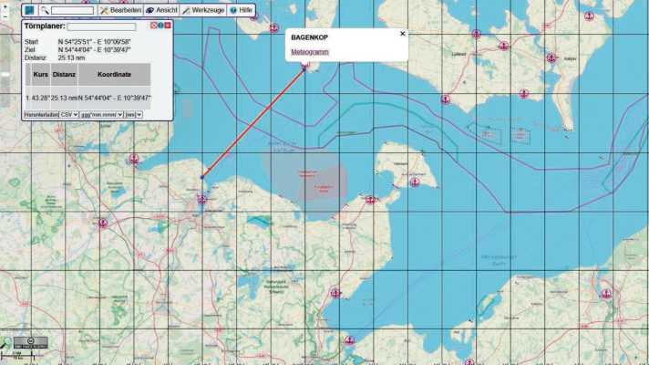
The free online service provides an overview of navigation marks and shipping routes, but no nautical charts with depth contours. However, there are depths that use individual measuring points from the community, but these are not comprehensive. Waypoints can be set with a click of the mouse, making OpenSeaMap suitable for an initial overview when planning a trip. In addition to the entire route, the route tool also calculates the distances between the individual waypoints. The planned route can also be exported in various file formats. An overlay with different weather data such as wind direction and strength as well as expected precipitation is also possible. AIS data from marine traffic can also be integrated. A nice feature is the full-screen map. In this view, the nautical chart fills almost the entire screen. This makes it particularly easy and convenient to explore routes and destinations. More information: openseamap.org
Route planning tool
Overlay weather data
Overlay AIS data
Good view
No area-wide depth information
Google.com/Maps
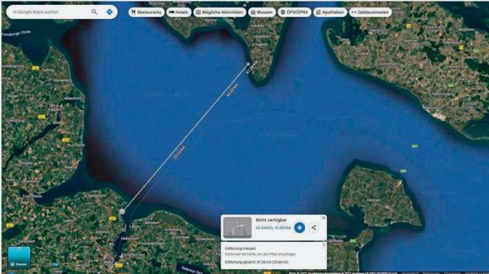
At first glance, the free map service does not offer any added value for sailors, but can score points as a quick overview. Yes, distances can be measured, but that is not the real strength. This lies in the comprehensive satellite images. This allows the user to quickly find out whether there is a sandy beach in a potential anchorage, and sometimes the popularity of the spot can be deduced from the anchormen in the image. The worldwide overview is unbeatable. In addition, shops in harbours are directly linked and with one click you can see opening times and possibly even the range of products on the website. Restaurants and places of interest can also be found quickly. The actual route is then created using a suitable planning tool. If crew changes are planned, the journey by train can also be planned and the nearest harbour can be found. More information: google.com/maps
Good overview thanks to satellite images
Simple distance measurements possible
Shops and restaurants linked
No nautical charts
No route planning on the water
Skippo.dk
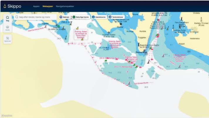
Formerly known as Eniro, the new service offers charts of Danish, Swedish, Finnish and Norwegian waters. However, these can only be used by calling up the Danish site (.dk) directly. The Swedish website does not contain any charts of Danish waters. The nautical charts include detailed depth information and all sea marks on land and on the water. That's nice for planning. Unfortunately, Skippo does not offer nautical charts of the German coast. The charts also contain helpful markings for anchorages, harbours, restaurants and petrol stations. Otherwise, the free service offers very few functions, for example it is not possible to measure distances. There is also no route function in the free version. This can be activated for 399 Swedish kronor (currently around 36 euros) per year. Then there is also autorouting, weather data, anchor alarm and AIS targets. More information: skippo.dk
Detailed nautical charts for Scandinavia
Anchorages, harbours and restaurants marked
No distance measurement
No route function
No nautical charts of the German coast
Michael Rinck war das Kind, das nach der Schule direkt aufs Wasser wollte – Segeltraining, Regatten, Hauptsache nass. Diese Vorliebe machte er zum Beruf: Erst als Segellehrer auf der Alster (während des Studiums), dann ab 2014 in der YACHT-Redaktion. Dort hat er im Bereich Test & Technik seine Berufung gefunden: Segelboote und Sicherheitsequipment testen. Was besonders bei Rettungswesten und MOB-Systemen bedeutet, dass er mehr Arbeitsstunden im Wasser treibend verbringt als die meisten Menschen im Büro sitzend. Höhepunkt: eine ganze Nacht in der Rettungsinsel auf der Ostsee. Seine Familie hat inzwischen durchgesetzt, dass Urlaubstörns auf der eigenen Fahrtenyacht deutlich trockener ablaufen.


