Meteorology episode 2: How highs and lows form
- Part 1: The basics.Wind, air pressure, temperature, humidity and more. What changes these parameters cause in combination
- Part 2: Of highs and lows. What influence the pressure formations have on wind development, how they develop and which constellations can be dangerous for sailors under certain circumstances
- Part 3: Weather risks. Whether fog or thunderstorms, hail or hurricanes: How sailors can recognise early on that trouble is imminent. Plus: How local effects influence the weather on site
- Part 4: Route planning. Using weather information, special services and apps to optimally prepare your own trip - how to do this and what you should pay attention to as much as possible
Part 2: Under pressure- of highs and lows
by Sebastian Wache
After the basics in the first part, let's now think a few dimensions bigger: this text will focus on the pressure systems in the atmosphere. But before we analyse them, we first need to look at how, where and why they are created in the first place. To do this, let's take our minds off the Earth and imagine that we are looking down on our home planet from the ISS space station. In addition to the large blue portion of the oceans and the dark land areas, the many and large white patches immediately catch the eye: the clouds.
On closer inspection, clear patterns can even be recognised. At the height of the equator, for example, there is a real band of clouds that stretches around the entire globe. In this band, the clouds often appear really bright white. This is because they can grow very high in the equatorial region - right up to the ice. They form the highest form of cumulus clouds. More on this later when we talk about the cold front. Let's first look a little further north from space. A few smaller, often loose cumulus clouds usually catch the eye until we reach a latitude of around 30 degrees north. There we often discover a huge cloud-free area. Only over the water areas is the sky not always completely free of clouds.
The cause of this phenomenon: around 30 degrees north, a sinking process takes place in the atmosphere: Air falls from top to bottom, warming up in the process so that clouds can dissolve as a result. We remember the first part of the weather series More pressure generates heat, keyword air pump. There is a wide-ranging belt of high pressure at latitude, for example the Azores High.
However, as air masses coming from above have to go somewhere later on the ground, they flow out of the centre of the high. In this respect, we had learnt that air always flows from high to low pressure. This means that the air moves from 30 degrees north and the high back to where it came from: towards the equator and the low pressure trough there. This is also known as the intra-tropical convergence zone.
The air movements there are nothing other than the notorious trade winds. As they are deflected to the right due to the Earth's rotation, the winds do not come directly from the north, but rather from the north-east. The trade winds from the northern and southern hemispheres then meet at the equator.
Wind and cloud formation
In addition to the strong sun, which heats the air directly and therefore very strongly, the converging winds also promote cloud formation. The winds also cancel each other out, so that in the so-called Doldrums (see below) very shallow near the equator. This circulation on the ground from 30 degrees north or south to the equator and vice versa at an altitude of around 18 kilometres from the equator to 30 degrees north and south is known as the Hadley cell.
In addition to this cell, there are two others: the polar cell produces a wind flow from the pole to around 60 degrees north on the ground and back at altitude. This polar cold high can thus transport cooler air masses to the warmer south. The Ferrel cell also exists between it and the Hadley cell, i.e. between 30 and 60 degrees north. It is externally controlled by the other two and is therefore a passive cell. Nevertheless, it is largely responsible for our weather: it often sends us warm air masses from the high pressure belt, which in our case is usually the Azores High. However, there is a small problem right at the height of the North Sea and Baltic Sea: this is where the Ferrel cell meets the polar cell. This means that warm air from the south meets cold air from the north. The air masses are initially separated from each other by a natural barrier. We call this the air mass boundary or polar front.
However, warm air is lighter and can also expand further. Cold air behaves in exactly the opposite way. If we now go up a few levels in the atmosphere, we can see that, for example, the areas in which we only measure 500 hPa air pressure - or 300 hPa - are at very different heights in the two air masses. Over Europe, the areas with an air pressure of 300 hPa near the air mass boundary on the warm side are around 10.2 kilometres above sea level, while on the cold side they are only 9.7 kilometres above sea level. And very close to each other. There is therefore a marked jump in the pressure level at altitude. This also needs to be equalised.
The jet stream
A strong wind is responsible for this: the so-called jet stream. It is easy to imagine that this wind band, which also meanders around the entire earth, becomes stronger when the temperature differences are greater. Then the upward expansion of the air column is also stronger and thus the height of the pressure levels in a small space.
The polar front can therefore always be found below the jet stream. Now there is an additional factor, because the air masses are still strictly separated at the front and not much would happen. If something is to happen, i.e. weather activity, then this polar front has to move. This also happens via the strong wind band at altitude: in normal conditions, the wind in this band moves from west to east. However, as the entire column of air is interconnected, flows around or over obstacles on the ground - for example the Rocky Mountains, Greenland or the Norwegian mountains - have an effect on the entire system. The obstacles on the ground therefore also change the flow behaviour of the strong wind band at altitude; the jet stream begins to meander, i.e. it takes on a wavy shape.
Cold air can penetrate further south into warmer regions and warm air further north, where it is colder. In addition, this flow behaviour causes the air masses to curve and swirl. We often see this near Iceland: a typical Icelandic low forms.
Rule of thumb for low pressure areas
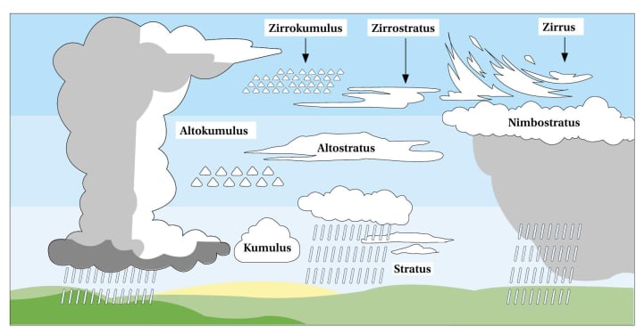
Now place a slightly open fist in front of you in such a way that you could still hold a bottle with your thumb pointing upwards. The so-called right hand rule shows how the air blows around a low in our area and where the air inside the low flows. The anti-clockwise winds meet in the centre and rise upwards. However, the air masses do not collide directly at first, but are still separated from each other due to their density and temperature differences. If such a low moves from Iceland towards the Baltic Sea, for example, the wind on its eastern flank blows from a southerly direction. Warm air is transported northwards. It initially glides slowly on the cold air in front of it. And it brings a little more moisture with it. This causes clouds to form higher up. Cirrus clouds are therefore typical harbingers of a warm front. As the warm air gradually replaces the cold air on the ground as well, the process of the upward glide continues downwards. This means that after the ice clouds at altitude, further so-called stratus clouds build up until the cloud cover is also closed at a height of around two kilometres. It then usually becomes noticeably warmer on the ground: we are in the so-called warm sector.
Depending on the extent of the sector, it may then be warm and sunny for longer. However, a cold front will follow sooner with the same or perhaps later with another low. This is because this low pressure swirl also brings cold air masses from the north on its back. And these are usually the most spectacular events in our weather. We know that warmer air can store more moisture. Now imagine we have a hot summer day with 30 degrees Celsius or more. If there is also a certain amount of moisture in the air, then it not only feels humid, but there is literally "a thunderstorm in the air".
When a cold front meets warm air
So we have plenty of energy in the atmosphere. Now we basically just need a match to start the "explosion". If the cold front moves in quickly from the west, it usually happens very quickly. This is because the cold air that follows behind this front is not only pushed in at ground level. In fact, the entire column of air is cold. The cold front rolls into the warm, moist air like a snow plough. The friction on the ground slows the front down a little. And so the cold air overtakes itself at altitude and runs slightly ahead of it there.
At this point, we are dealing with a so-called unstable stratification at altitude. Suddenly the cold air lies above the still warm air on the ground. Nature wants to equalise this once again and does so, and does so abruptly! The cold sinks down and displaces the warmth, which is driven upwards at breakneck speed. It cools down in the process, releasing water vapour and creating clouds. As everything happens so quickly, the clouds shoot upwards like springs into the icy part of the atmosphere. In contrast to the warm front, in which clouds slowly build up. This vertical growth of the clouds, also known as convection, releases additional energy from the air parcel. This in turn is used so that in our latitudes the clouds can eventually pile up to a height of twelve kilometres in summer.
But then it's over. This is because the stratosphere begins at this altitude, where the natural ozone absorbs a lot of solar radiation. Here, a warm layer lies above a cold one. This is stable and prevents further cloud growth. From an altitude of around seven kilometres, we are already in the ice zone. There, the frozen cumulonimbus clouds fibre out on all sides. A veritable textbook cloud anvil forms. It is also this formation that brings heavy rain, hail and thunderstorms.
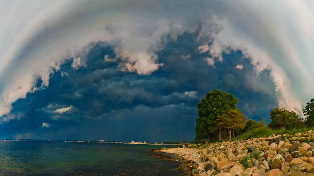
But back to the image of the snow plough: if the air at altitude runs ahead of the air on the ground, it is understandable that a certain amount of rotation can occur. A situation that favours a so-called gust roll, the arcus cloud. This is a very striking phenomenon that often stretches across the entire width and stands out from the dark wall of thunderstorms.
There is already a lot of pressure in there, often before the rain comes. But the rain is usually followed by another strong wind, because the so-called evaporative cooling also plays a role within a cloud. Everyone knows it when they come out of the water after swimming and a light wind is blowing. You get cold quite quickly if you don't dry off quickly. This also happens in the cloud tower. Not only does it rain down, it also cools itself down. Cold air is heavier, however, and so it literally rushes out of the white spring towers towards the ground. These squalls are usually the greatest danger if you don't reduce your sail area early on. The good thing is that cold fronts often pass through after just 30 minutes due to the speed at which they move. Behind them, the temperature drops noticeably. In summer, this can result in temperature differences of 15 degrees Celsius within a short space of time in the same place.
Occlusion brings colder air and showers
The third front in a low pressure system is the occlusion. This is a mixed front in which the warm and cold fronts have already merged. The low therefore has hardly any temperature contrasts that interfere with each other - which is why such a low does not last long.
However, these types of fronts also bring weather with them. Usually in a similar way to cold fronts, as the air behind the front is often somewhat cooler than in front of it. Here, too, showers are more likely than prolonged land rain.
And there is another line that can always be seen on weather maps. It is usually shown in black and extends across the isobars, the lines of equal atmospheric pressure. These are rear troughs, i.e. trough lines on the back of lows. Air masses usually converge there as well, lifting takes place - and on the western and therefore cold side of the lows. These lines and the weather associated with them should therefore not be underestimated. In extreme cases, troughs can bring more severe weather than a preceding cold or occluded front.
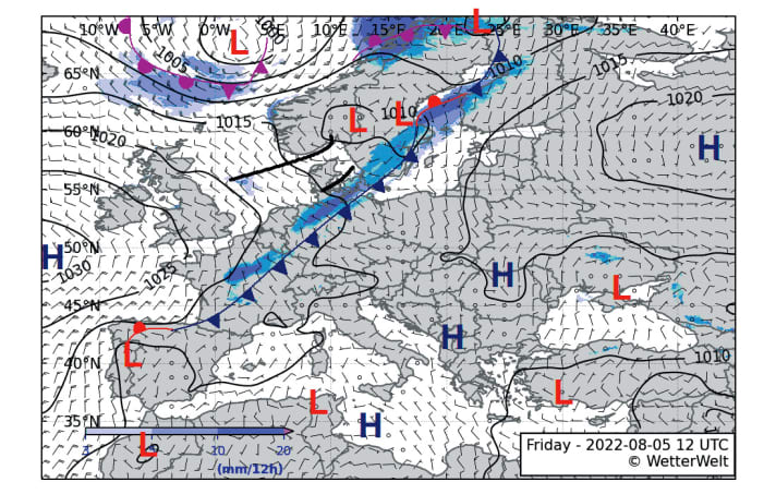
The barometer is one of the indicators of whether a trough will follow. For example, if it does not rise strongly enough after the passage of a cold front, but possibly falls again a short time later, we can expect another strong pressure passage. The wind direction can also be an indicator: Ideally, the wind behind a low turns to the north-west after all fronts. If it does not do this, or does not do so completely, but even turns back to the south-west, this also indicates a trough passage.
So let's summarise: We learnt about the basic parameters in the first part and now we will look at what actually constitutes lows and highs and how they develop. We also discussed the fronts and the first weather hazards, particularly in connection with the cold front. But these are not the only weather hazards that sailors can face. Some even occur when there is no wind and it is completely calm. Other dangers are localised and tend to recur regularly. And still other weather hazards need only be feared at certain times of the year. What's more, even weather constellations that originate thousands of kilometres away from us can reach us and really upset our weather systems on the North and Baltic Seas or inland.
This is what the third part will be about. Now that we have looked at the big picture, we will - at least partially - go back to a smaller scale. Until then, we should remember that the weather should always be viewed globally. It is characterised by three cells in both the northern and southern hemispheres. The polar and Ferrel cells meet in our latitudes. The zone where cold and warm air masses meet is called the polar front; areas of low pressure form along it and the global jet stream lies above it. And: lows carry warm and cold air in particular with their fronts.
The Doldrums
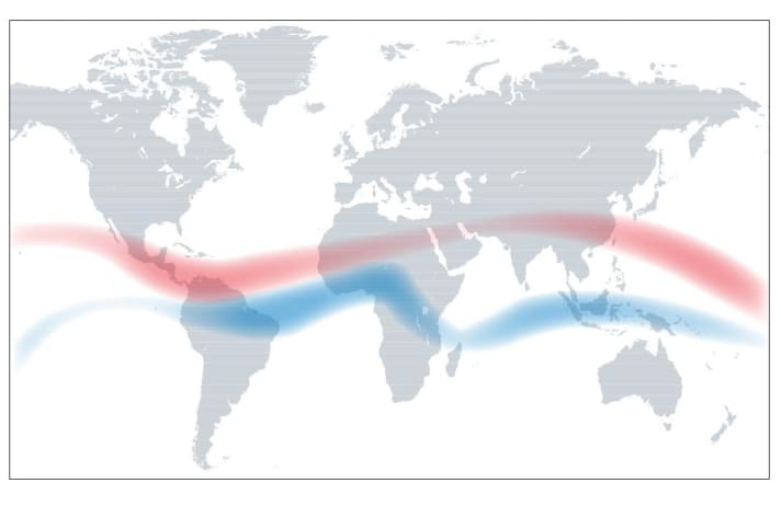
The so-called intra-tropical convergence zone is a low-pressure belt that runs once around the earth at the height of the equator. The trade winds from the northern and southern hemispheres meet in this area. As a result, there are usually only very weak winds there. However, this zone shifts with the seasons. In the northern or southern summer (see diagram), the belt shifts, especially over land, to ten degrees north or south in some cases. There are also shifts over the water. This influences the trade winds. If the south-easterly trade winds reach the northern hemisphere, they are deflected to the right and become south-westerly winds. The north-east trade winds, on the other hand, can be forced to cross the equator in the southern summer and experience a left-hand deflection there. They then blow from the north-west.
Caution with wind against current
With wind direction, we always talk about where the wind is coming from. With the water current, on the other hand, we are talking about where it is going. So if the GRIB data shows the same directional values for wind and current, then we may be dealing with a wind-versus-current situation that is dangerous for sailors!
The Coriolis force
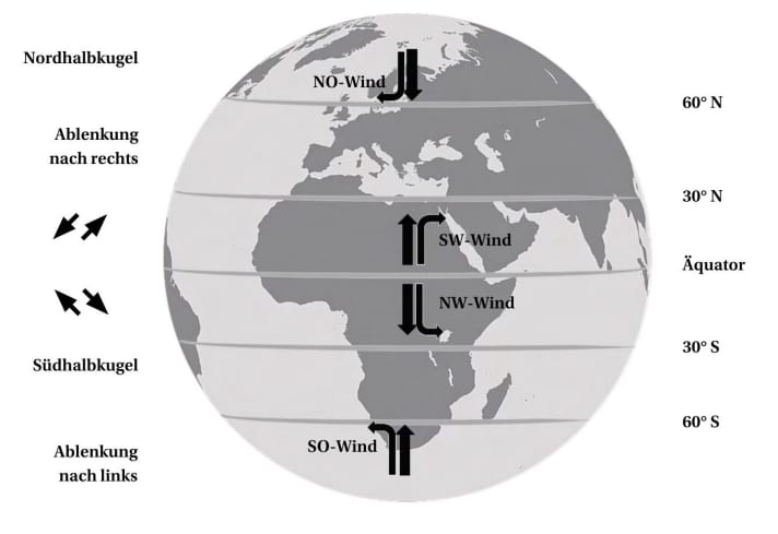
It is a so-called apparent force. No one is pulling on the air masses themselves. Instead, they are deflected solely by the Earth's rotation, as they are not directly connected to the Earth. As if that wasn't enough, the earth also rotates at different speeds. Faster at the equator than at the poles, where the axis of rotation is located. Imagine sitting on a swivel chair and holding someone's hand. You turn round the chair's axis and the person holding your hand runs round the chair at breakneck speed. Air masses coming from the north are slower than the earth beneath them. This causes the earth to turn away from the air, which is deflected to the right in the northern hemisphere. If the air comes from the equator and flows northwards, it takes the speed of the zero latitude with it and runs slightly ahead of the slower earth, also with a right deflection. In the southern hemisphere, on the other hand, it moves to the left.
Cloud science
Cirrus clouds form not only when the warm front glides up and reaches the ice area, but also when the source clouds of a cold front are formed high up and also freeze at altitude. Cirrus clouds are often regarded as harbingers of warm fronts. However, if the somewhat stronger high-altitude wind should now carry the cirrus clouds of a cumulonimbus cloud of a cold front so far ahead that they are the only type of cloud that can be seen from a great distance, then the following applies: You can be wrong about cirrus clouds! So you don't yet know which of the two fronts is coming. The further course of the clouds should be observed. If the clouds continue to build up, the situation remains relaxed and it could rain. However, if they start to swell, it makes sense to quickly prepare for bad weather or even thunderstorms.
The author: Sebastian Wache

Sebastian Wache is a qualified meteorologist; he works as an expert in marine weather forecasting and professional weather routing as well as a cruising and regatta consultant at Wetterwelt GmbH in Kiel. He regularly passes on his knowledge to sailors in seminars and also presents the daily forecast for Schleswig-Holstein on NDR television together with Dr Meeno Schrader. Wache is a keen sailor himself and enjoys sailing on the North Sea and Baltic Sea.

