Baltic Sea storm surge: Secure your yacht!
YACHT
· 19.10.2023

By Sebastian Wache
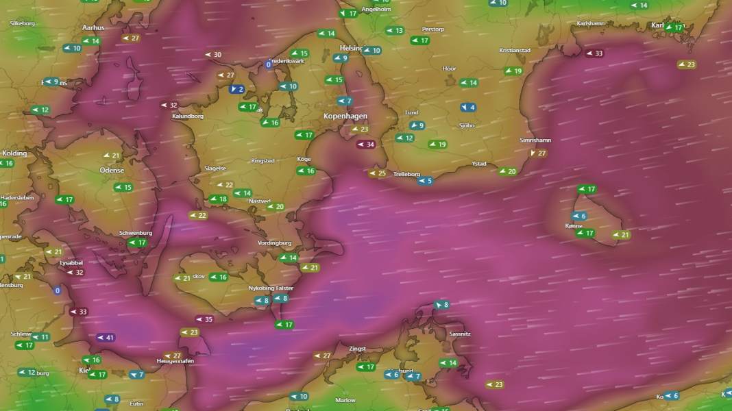
On Wednesday, a few boats could still be seen on the water under blue skies and a light south-easterly wind. But less than 18 hours later, the picture was completely different. Thick clouds, rain and, above all, storms and rising water levels on the Baltic Sea.
What happened? The high that ensured a golden October the day before was pushed towards Sweden by Atlantic lows. However, it has now settled there for three days. At the same time, however, strong Atlantic lows continue to push against the high. As a result, the isobars are pushing harder and harder.
Every sailor knows this from the weather charts. The wind picks up. And the closer these lines are, the stronger it blows. And if you look at the weather charts, you can see step by step how these lines are getting tighter and tighter. So there is a threat of a storm or even gale-force gusts. All of this from an easterly direction. A storm surge is usually associated with the North Sea and a strong westerly low. But now we have a so-called "high over low" situation. In other words, a high in the north over a low on the map of Europe. This inevitably results in an easterly wind between the two systems.
Scandinavian highs
They are often associated with good weather. But in autumn, unlike in summer, things usually look different. Although the highs remain over northern Europe for quite a long time, they are nowhere near as extensive and full of warm air. In addition, due to the temperature contrasts with already cold air in the north and still warm air in the south, the lows have enough basic ingredients to turn out to be very strong. We now have a Scandinavian high, which occurs around three times a year. But with a very strong low-pressure influence on its southern edge.
And as water offers very little friction surface, the wind is hardly slowed down at all. The cold air can take off from the Baltic and rush towards the Baltic coast of Germany and Denmark almost unchecked.
Free approach to the German coast
The wind pressure will cause the water to build up on the coast. The water levels in the Baltic Sea rise. They often do this even after the influence of low pressure with little or no wind. This is known as the bathtub effect. The water pushed towards the eastern Baltic Sea by the westerly wind simply sloshes back again. This can also lead to 1 to 1.20 metres above normal and flood the jetties in the harbours. We had a situation like this just a fortnight ago. It's something of a regular occurrence.
However, this time the weather conditions were able to allow a little more water to flow into the Baltic Sea via the Skagerrak and Kattegat, so that the water level had already risen slightly by up to 20 centimetres before the easterly wind arrived. Now the storm is also coming, which will last for more than 48 hours due to the stationary position of the high pressure system and will gradually increase in strength. I see the peak on Friday and Saturday night with gusts of 120 to 130 km/h.
The water levels begin to fall on Saturday
That would put us in the hurricane force range. The high over Sweden will only move a few kilometres towards Finland on Saturday night, which will be enough for the low to move northwards towards the North Sea. As a result, the wind will probably turn right to the south relatively suddenly early on Saturday morning and ease. This will be enough for the water levels to start dropping immediately.
But until that time comes, they are rising, and considerably so. To levels we haven't seen since 2017. Back then, the water in Flensburg, for example, reached almost 1.80 metres. Sandbags and bulkheads had to protect houses. Cars parked in the harbour were also submerged, as was the case in Lübeck on the Trave and in Wismar. This time, however, it could go one step higher. If the water level is between 1.50 and 2 metres above normal, we are talking about a severe Baltic Sea flood or a severe Baltic Sea storm surge. From a level of 2 metres, it is even a very severe one. And the BSH (Federal Maritime and Hydrographic Agency) forecast and the Danish weather service DMI with its water level models in and around Flensburg and Sonderborg are now predicting a maximum level of up to 2 metres or even higher.
In particular, the slight southeasterly winds ensure that the water pools in the direction of the Flensburg Fjord as if in a funnel. This means that the highest water levels along the entire German Baltic coast are expected here. However, the possible 1.60 to 1.80 metres in Lübeck and Kiel will also cause the water to overflow its banks. The waves of the whipped-up sea also contribute to this. You're lucky if you can lie on a floating jetty. But these are in the minority in the Baltic Sea.
At the same time, the stark opposite is happening in the North Sea. There, the water is pushed away from the coasts. Low tides of -1.50 to -2.00 metres are to be expected here. The ferries to the islands have already announced that they will not be able to sail as there is no longer enough water.
And in general, the wind will also cause some damage in the north. Be it badly attached winter tarpaulins or sails that are still attached to boats moored in the harbours. The big clean-up will start on Saturday, when we have survived the worst of it, but until then we have to get through the 48 hours of constant storms and high tide.
The author

Sebastian Wache is a qualified meteorologist; he works as an expert in marine weather forecasting and professional weather routing as well as a cruising and regatta consultant at Wetterwelt GmbH in Kiel. He regularly passes on his knowledge to sailors in seminars and also presents the daily forecast for Schleswig-Holstein on NDR television together with Dr Meeno Schrader. Wache is a keen sailor himself and enjoys sailing on the North Sea and Baltic Sea.

