

In this test:
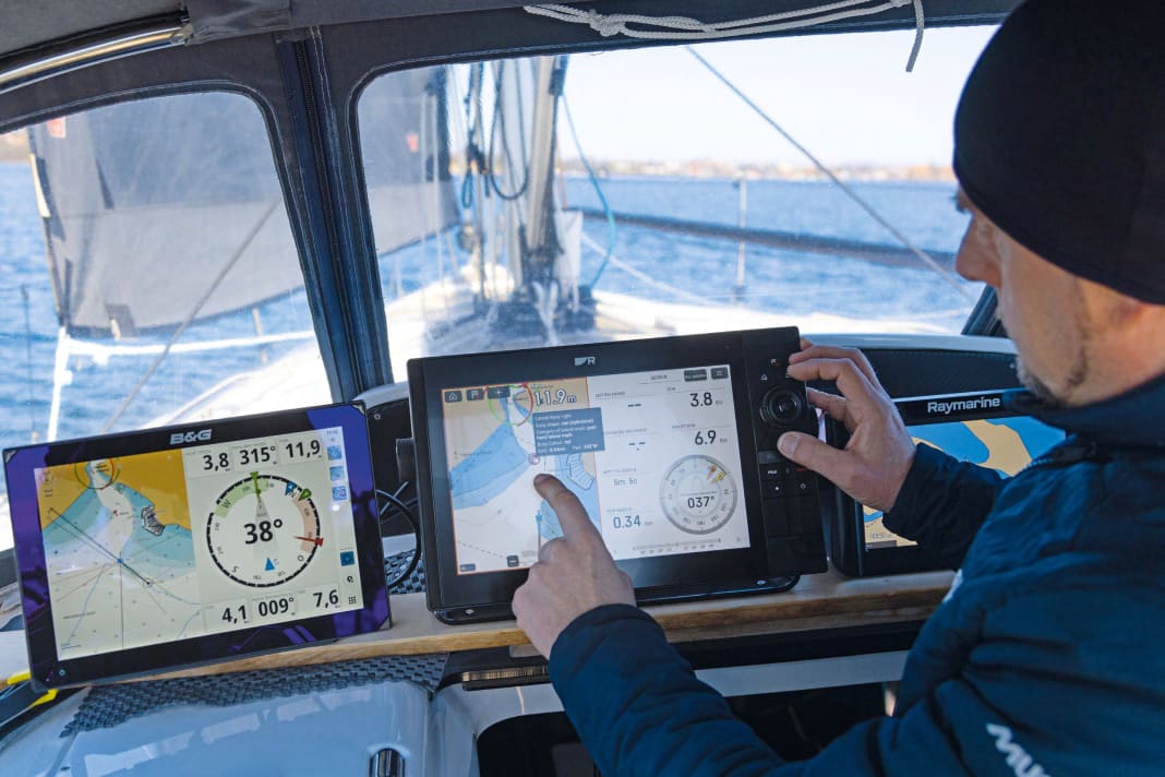
Just in time for boot in Düsseldorf, B&G and Raymarine presented new multifunction displays. The Finnish manufacturer Q-Experience is a completely new competitor. However, the devices are not necessarily in the same class. While the Zeus S, the successor to the Vulcan series, is at the lower end of the B&G portfolio, the Axiom 2 Pro is the new top model from Raymarine. The two are around 1,200 euros apart. In other words, the Axiom 2 Pro is almost twice as expensive as the Zeus S. The Q2 display from Q-Experience lies roughly between the two. So is it a comparison of apples and pears?
Yes and no, because this article should not and cannot be a comparison like the last plotter test in YACHT 24/2019. The devices are too different for that. Rather, the aim is to test the latest developments for their practical suitability and to highlight the differences.
All plotters run Android systems with beautifully tidy user interfaces
Firstly, the similarities: All three manufacturers now rely on Android for their operating systems. The individual functions of the plotters are then organised into apps. This is accompanied by comparatively tidy user interfaces that can be operated without studying the manual if necessary. In view of the wide range of functions of the devices, this is a remarkable achievement and a good thing, as the Zeus S was so new when we tested it that Navico was only able to provide us with a preliminary quick start guide. Delivery of the series models had not yet begun and the manual was not yet available. Raymarine also had delivery problems. Although the manufacturer offers a very detailed manual, all available series devices had already been dispatched to customers.
We therefore had to switch to test samples with a 12-inch display. The display size does not play a role in the assessment of functions, software and operation, so the findings should be directly transferable to the 9-inch models.
The simple setup is pleasing. Axiom and Zeus S request the data required for operation via well-structured setup wizards. The Q2 display starts operation even without information about the boat.
Straightforward commissioning - Netflix on board
All three plotters automatically recognised the transducers in the NMEA 2000 on-board network on the test boat, and the data could be retrieved by the devices without further action. There were five GPS sources and two compasses to choose from. There was also an AIS transponder, wind measurement system, echo sounder, log and water temperature sensor.
If you want to know exactly which transducer is used for the respective function, you have to check the source overview. This was also easy for all plotters, with the B&G display being the clearest and Raymarine offering the most diagnostic functions.
However, user-friendliness is not the main reason for using Android. Rather, the focus is on the simple integration of external apps. Regardless of whether this involves monitoring and controlling boat components or playing multimedia content.
The apps from Netflix, Spotify and the remote desktop service Anydesk are installed on the Axiom 2 Pro by default, but other programmes approved by Raymarine can also be added. B&G does not yet allow third-party apps.
Always online, the new addition to the motorboat segment has built-in Internet access
The Finnish manufacturer Q-Experience goes one step further when it comes to integrating online services: the Q2 display can not only be connected to a mobile phone or hotspot, but also comes with Internet access. Provided it has the right SIM card, the device is always online. Location-based searches via Google and Google Maps are integrated directly into the navigation menu. Q-Experience has been active as a manufacturer of navigation systems for around six years, but has limited itself to the motorboat market. More specifically, complete solutions for Scandinavian shipyards such as Buster, Yamarin and Askeladden.
There, the multifunctional displays are offered with customised software under the respective shipyard name. The plotters have only been available in Germany as a stand-alone product under the name Q2-Display since the beginning of the year.
The Finnish manufacturer also works together with the French instrument manufacturer NKE. However, their customised version was not yet available for the test. With the current software, the Q2 display only has rudimentary sailing functions, but offers interesting zoom functions. We were curious about the autorouting of the devices. In the 2019 test, no plotter provided a really usable and safe route. In order for the automatic route guidance to work, detailed nautical charts are required first and foremost. There are obviously still significant differences at this point. While the route guidance of the Q2, which works with Navionics data, leads safely through fairways and bridge crossings, the Zeus S, which is equipped with C-Map charts, takes some shortcuts over shallows, which it also warns of with a red route. The Axiom 2 Pro does not currently support autorouting with the tested Lighthouse charts. A compatible Navionics chip was not available to us for the current test.
Overlaid laylines
If the destination is upwind, you have to tack, but when is the best time to tack? With two of the three plotters presented here, laylines, i.e. layline courses, displayed on the chart help to answer this question. The two upwind courses can be displayed either at the current position or as laylines at the waypoint. In either case, they show the possible paths to windward. This makes it possible to recognise whether a turn to the waypoint makes sense or is still too early. Especially if the wind shifts are also displayed as fans. The laylines can be determined according to a fixed tacking angle or according to polar data. In this case, however, the courses are those on which you can get to windward the quickest.
A practical variant for cruising sailors are laylines that are based on the current wind angle: The plotter then determines the course at the same height, but on the other bow. This means that sea conditions, sail trim and steering habits are automatically taken into account. In short, it is more likely that the destination can actually be reached on the new bow. The whole thing also makes sense on the room sheet: if you cross before the wind, it is clear when the headsail will safely come out of the lee of the main again after the jibe.
Sun is not a problem for any plotter, but touch operation is not always perfect.
With older devices, it is often difficult to see much of the display in bright sunlight or from the side. Thanks to powerful backlighting and high contrast, none of the three plotters have a problem with this. Only Raymarine and Q-Experience offer automatic brightness control, as we are used to from smartphones. While the Zeus S has to be dimmed manually at dusk and switched to night mode, the Axiom 2 Pro adjusts the display brightness automatically using a light sensor. The automatic control of the Q2 display works in a similar way, but also switches to night mode if required.
The Zeus S and Q2 can only be controlled via the screen, while the Axiom 2 Pro also has a rotary knob with cursor field and buttons. This means it can cope with any weather and is easy to operate even when wearing gloves.
The touch display from Raymarine is in a class of its own. Not only does it respond very directly and reliably, but it is also slightly matt, which causes far fewer reflections. The water and grease-repellent coating also works much better than on any other plotter tested to date. No fingerprints are visible on the Axiom, and splash water runs off so well that hardly any salt or limescale remains after evaporation. The display of the Zeus S in particular had significantly more problems with this and also did not react to every finger touch.
New plotter #1: B&G Zeus S (1,700 euros)
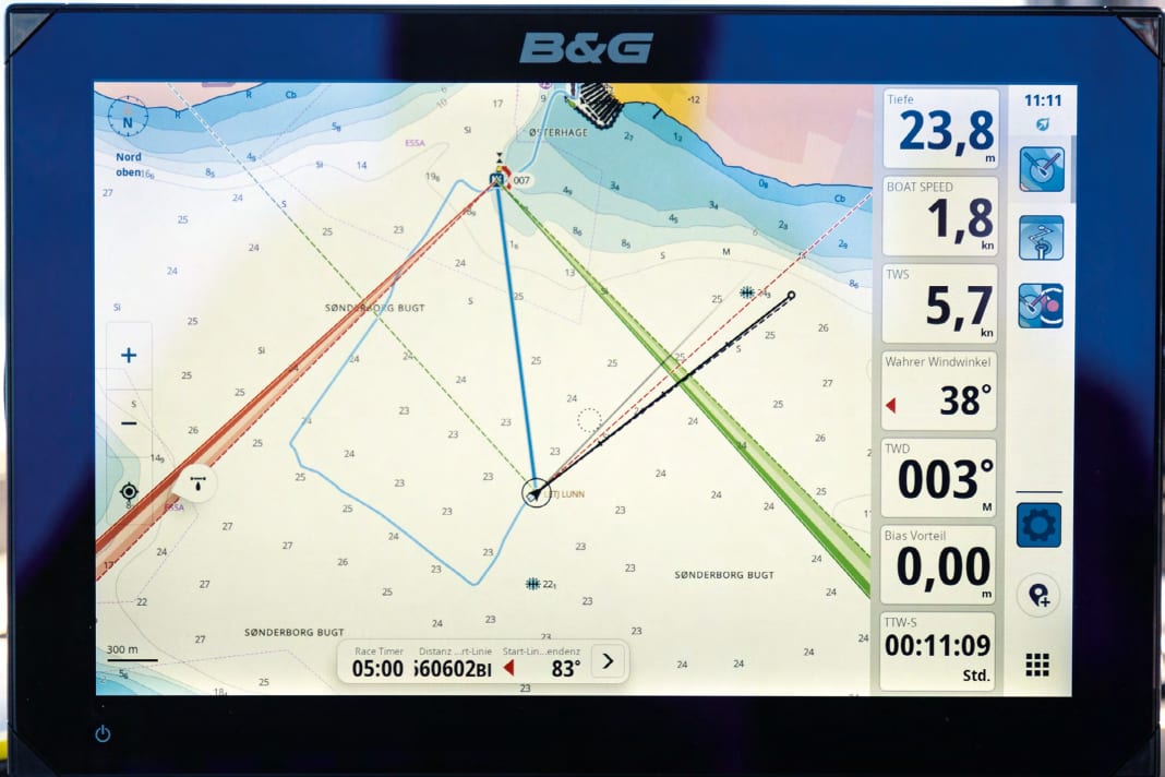


B&G remains true to itself with the Zeus S and focusses fully on sailing and regatta functions. The hardware and software are a completely new development, which was noticeable in the pre-production model supplied for the test with one or two hitches. Even booting up took a comparatively long time. It took a good minute for the nautical chart to load, and the touchscreen did not react as reliably as you would expect from a navigation device. The skin moisture of the fingers played a major role in this. In contrast, the new user interface is a real gain.
The menu structure is much clearer than on the previous models. We particularly liked the fully customisable data bar, which means that the desired information is always in view. Various pages can be scrolled through by swiping sideways, and the size can be easily increased if required. The familiar Sailsteer display is still there, but it can no longer be shown as an overlay in the maps. No great loss, because it was so small that it was confusing. Instead, the laylines in the charts now not only show wind shifts in the form of hatched compartments, but also give the impression of a trend. The more frequently the wind direction occurs, the darker the hatching becomes. Waypoints can be easily set in the map view. For precise positioning, however, it is advisable to take a diversion via the route planning view, as it offers a crosshair. There you will also find the autorouting function, which can be used in sections. However, the calculated routes should be checked carefully. Regatta sailors will be pleased with the menu for creating a course. The course and rounding of the buoys can be defined with just a few taps.
- Price, 9 inch:1,700 Euro
- Resolution in pixels:1.280 x 720
- Operation: Touch
- card system:C-Map
- Power consumption in standby mode:0,003 A
- Power consumption at 12 volts:0,82-1,74 A
- Time to boot up:1:02 minutes
- GPS:10Hz, WASS, MSAS, Egnos
- Interfaces:N2K, USB, Ethernet
- Distribution: bandg.com
New plotter #2: Q-Experience Q2 display (2,599 euros)
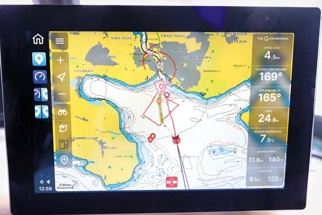


The Finnish navigation device is reminiscent of a built-in tablet. At least the display responds as well as you would expect from premium tablets. The user interface is easy to understand and simple to operate. As the Q2 display was designed for motorboats, there are hardly any sailing-specific functions. True and apparent wind can be displayed. However, no damping can be set, so the values fidget as they are provided by the transducers. The calculation of times to be sailed to the waypoint or laylines projected onto the chart are not available.
There is no switch, instead there is an ignition contact which starts the plotter as soon as it is switched to positive. It takes a full 28 seconds to boot up, including loading the Navionics chart. It is stored in the device's memory and can be loaded and updated via Wi-Fi. The chart slot does not need to be accessible. To use the online functions, the Q2 display requires internet access via Wi-Fi or the built-in 4G modem.
The Finns rely entirely on autorouting for route planning, which works impressively well, even a 560-mile tour from the Danish South Sea to Turku showed no anomalies. However, the software had problems displaying all the map information. For example, it was not possible to retrieve beacon identifiers for all beacons.
The overview and look-ahead functions are interesting. Pressing the bird symbol zooms out temporarily to orientate yourself in narrow waters. The binoculars can be used to look ahead along the course. Great! The Q2 display is compatible with Raymarine sonar transmitters and radar antennas.
- Price, 9 inch:2,599 Euro
- Resolution in pixels:1.280 x 800
- Operation:Touch
- card system:Navionics
- Power consumption in standby mode:0,05-0,120 A
- Power consumption at 12 volts:0,70-1,27 A
- Time to boot up:28 seconds
- GPS: Not specified
- Interfaces:N2K, USB, Ethernet, Audio
- Distribution: ferropilot.com , theqexperience.com
New plotter #3: Raymarine Axiom 2 Pro (2,960 Euro)
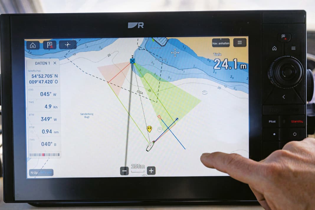


The Axiom 2 Pro is a real multi-tool, aimed at sailors, motor boaters and ambitious fishermen. The plotter's software covers everything and of course also works with Raymarine's camera systems to display sea marks, waypoints and AIS data as virtual reality. DJI Mavic drones can also be controlled via the display. Nevertheless, operation is relatively easy, as the functions are organised in different apps. In addition, the view and settings can be influenced via predefined modes, so you are not overwhelmed by the choice. Most sailors will probably get by with the three map modes "Detailed", "Anchor" and "Regatta".
The display is a stunner. The matt finish means there are few reflections and the touchscreen is extremely precise and weather-independent. The software and hardware are also well harmonised. The plotter starts up very quickly and loads smoothly.
Approach courses can be displayed on the chart, both at the waypoint and on the ship. You can choose between fixed wind angles or polar data. The integrated database provides polar data for many standard yachts, but sometimes it is not possible to recognise the model year for which the values are intended. Wind shifts can be displayed as coloured compartments, whereby the averaging interval can be set. There is no weighting as with the Zeus S. The sail control display is also not quite as detailed as on the B&G.
We used the plotter with Lighthouse charts from Raymarine, but C-Map, Navionics or some raster charts can also be used, and even the S-57 and S-63 commercial navigation standards are supported.
Lighthouse charts
For around a year now, Raymarine has also been offering its electronic nautical charts called Lighthouse Charts for Europe. Previously, the charts were organised by country. This meant that three sets of charts had to be purchased for a trip to Sweden, for example. This is now changing. In addition to the small sets, there will be three large sets in future - for Western Europe, Northern Europe and the Mediterranean. Baltic Sea sailors in particular will benefit from this, as one chart can cover the entire Baltic Sea, including Norway, for around 220 euros.
- Price, 9 inch:2,960 Euro
- Resolution in pixels:1.280 x 720
- Operation:Touch + buttons and controller
- card system:Lighthouse, C-Map, Navionics, S-57, raster charts
- Power consumption in standby mode:0,023 A
- Power consumption at 12 volts:0,75-1,66 A
- Time to boot up:41 seconds
- GPS:10Hz, Galileo/Glonass/Beidou
- Interfaces:N2K, USB, Ethernet
- Distribution: raymarine.eu
All prices as at 05/2023
More on the subject of equipment:

Hauke Schmidt
Test & Technology editor
Hauke Schmidt was born in Hanau, Hesse, in 1974, but moved to the coast at the age of an Opti and grew up sailing dinghies and tall ships. School and semester breaks were used for extensive Baltic Sea cruises. During and after his oceanography studies in Kiel, he took part in various international research trips to tropical and polar regions. The focus was on ocean currents and their influence on climate change. Eventually he was drawn back to his home coast and to YACHT. He completed a traineeship there and has been working as an editor in the Test & Technology department since 2009. His core tasks include equipment and boat testing, as well as practical topics relating to electronics, seamanship and refits. As a passionate DIY enthusiast, he loves to spend his summers on the water with his family and winters working on his boat

