Storm surges: No more, but stronger!
YACHT
· 14.05.2025

The past storm surge season on the German North Sea and Baltic Sea coasts was characterised by an extraordinary event: On 23 August, the North Sea experienced a summer storm surge. This phenomenon is extremely rare, as storm surges usually occur in the winter months from October to April.
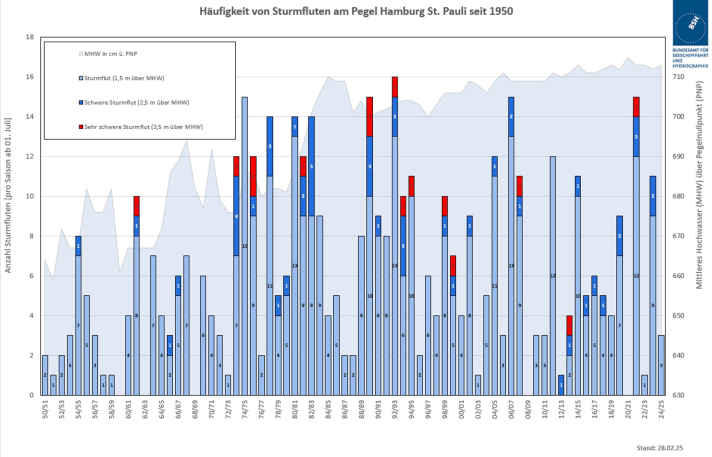
All in all, however, the 2024/25 season (the storm surge season statistically always begins on 1 July of each year) was calm. The BSH only recorded three storm surges on the German North Sea coast and two on the Baltic Sea coast. Nevertheless, experts are warning of growing risks caused by climate change.
Different accumulation of storm surges compared to the previous year
The BSH statistics, which have been kept since 1950, show clear fluctuations in the frequency of storm surges. An average of four to six per year occur on the North Sea coast and an average of three on the Baltic Sea. However, the deviations between the years are sometimes considerable.

For comparison: in the 2023/24 season, the BSH recorded 13 storm surges on the North Sea coast, including two severe ones. At the St. Pauli gauge, the water level rose to 3.33 metres above mean high tide. This high number was mainly favoured by unusually long-lasting, consistent wind conditions and the coincidence with the normal tide.
Important to know:
Different classification of storm surges in the North Sea and Baltic Sea
On the North Sea coast, the BSH distinguishes between different storm surge categories. A severe storm surge is when the water level is 2.50 metres above mean high tide. In the case of a very severe storm surge, the water level must be more than 3.5 metres above mean high tide. In the 2024/25 season, there were no severe or very severe storm surges on the North Sea coast.
Other criteria apply on the Baltic coast: Here, storm surges are categorised into four classes. A storm surge occurs when the water is at least one metre above the average water level. A medium storm surge is at least 1.25 metres, a severe storm surge is 1.5 metres and a very severe storm surge is more than two metres above the mean water level.
Forecast and warning of storm surges
The BSH plays a central role in forecasting and warning of storm surges. In co-operation with the German Weather Service (DWD), the BSH publishes daily water level forecasts for the North Sea and Baltic Sea. As a rule, water levels are published every six hours for the North Sea and twice a day for the Baltic Sea.
The Tide and water level forecasting service The BSH's water level forecasting system plays a key role in public safety and is part of Germany's critical infrastructure. To ensure the reliability of the forecasts, the BSH conducts dry runs several times a year to test the failure of system components of its water level forecast.
Increasing risks due to climate change
Dr Jennifer Brauch, Head of Forecasting Services at the BSH, warns of growing risks due to climate change: "We assume that the effects of storm surges will be more severe in the future." Rising sea levels are causing storm surges to rise higher.
Not so long ago: the devastating Baltic Sea storm surge of October 2023:
In Cuxhaven, the sea level has risen by 20 centimetres in the past 100 years. It could rise by a further metre by 2100, depending on the progression of climate change. "Sea level rise in combination with storm surges also increases the risk of more damage," explains Brauch.
Intensification of forecasting and cooperation
In view of the increasing risks, the BSH is intensifying its efforts to provide even more reliable water level forecasts, better services and increased exchange with other authorities and organisations. BSH President Helge Heegewaldt emphasises: "Our water level forecasting staff are on duty around the clock in the event of a storm surge. I would like to thank them very much for their excellent work to date, including during regular operations."
One example of the increased cooperation between authorities is the Natural hazard portal of the German Weather Service. The BSH's storm surge warnings are now also automatically fed into the portal. For the first time, the portal bundles all early warnings and precautionary information on weather-related natural hazards in Germany in a centralised location.
Storm surge definition North Sea:
- Severe storm surge: water level 2.50 m above mean high tide
- Very severe storm surge: water level more than 3.5 metres above mean high water
Storm surge definition Baltic Sea:
- Storm surge: water level at least 1 metre above mean sea level
- Mean storm surge: water level at least 1.25 m above mean sea level
- Severe storm surge: water level at least 1.5 metres above mean sea level
- Very severe storm surge: water level more than 2 metres above mean sea level
Average storm surge frequency:
- North Sea coast: 4-6 storm surges per year
- Baltic Sea coast: 3 storm surges per year

