Consequences of the Ukraine war: GPS disruptions: Astro navigation made easy via app
Jochen Rieker
· 16.03.2022

It is regarded as the Holy Grail of seafaring, and anyone who has studied astronavigation in depth knows that it can at least be described as the high school of position finding. Even those who have already learnt how to measure angles, calculate, compare and draw have to regain their routine after a winter season without dry runs.
This is probably one of the reasons why the use of a sextant and accompanying literature is a dying craft. Fewer and fewer skippers are taking up the training for a recreational offshore skipper's licence, which requires such skills. Even on professional ships, satellite navigation is now sufficient; no captain who has a redundant Ecdis system on board needs to carry a sextant any more.
Sailing yachts lack such technology, but even there the GPS plotter in all its variations has long since taken over. And since the launch of further international satellite systems at the latest, the worry of a failure seemed to be a thing of the past or at best theoretical.
Now, however, Putin's war of aggression against Ukraine shows that Astro is not obsolete after all. As YACHT editor Hauke Schmidt explained yesterday, land-based jamming transmitters operated by the Russian armed forces in the southern Baltic Sea are currently causing a partial failure of satellite positioning ( Direct link to the article, please click here! ). The Finnish transport authority Traficom has therefore already issued a warning.
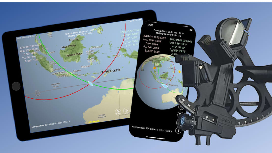
This is exactly the kind of scenario that Helmut Hoffrichter used to programme his free appCircle of Position Navigation has initiated. The owner of a Hanse 575 and long-time YACHT subscriber, himself a fascinated astro-fan, wants to reduce the complexity of determining a boat's position using the stars and thus radically simplify navigation.
In fact, with a little practice and a few theoretical basics, even non-experts can get to grips with the app. To obtain a location, all you need to do is measure two angles with the sextant - and the position is displayed on an electronic map, just like in the plotter.
Although you lose out on the magic of astro navigation, you save yourself all the hassle and, on top of that, the susceptibility to errors of classic astro methods. The app is currently only available for Apple iOS devices, but Helmut Hoffrichter says that an Android version will follow.
Read here,
Travelling with the sun
From Helmut Hoffrichter
When I had my first seaworthy boat, satellite navigation had been around for a long time, but I wanted to be able to navigate like the old sailors. So I bought a sextant and a book to learn how to do it and soon realised how to determine a location according to Marcq Saint Hilaire. After the first winter break, however, everything was forgotten again. The effort involved compared to satellite navigation was enormous. Table books, paper maps, blank maps, calculators and drawing utensils are an imposition in the 21st century.
The only difference between a star and a satellite is that a star, unlike a satellite, does not send out radio signals to inform a receiver of its distance. Its distance to a location must therefore be measured from the earth using a sextant. There are no other differences, apart from performance, and a computer is completely indifferent to the method of distance measurement. In both cases, it can calculate the location quite unspectacularly and display it on an electronic map as a ship symbol.

But why is there simply no getting away from the indirect altitude method operating with standard lines? In 100 years of worldwide seafaring, this Saint Hilaire altitude method has become so firmly established that it is now synonymous with astronavigation. In fact, it was born out of necessity because there were no computers. But strangely enough, today we have computers and astronomical navigation programmes simply imitate the cumbersome steps involved in constructing the contour lines of that time, with all their disadvantages.
In addition, a separate location must first be estimated and heights above 75° may not be used. The result is then not even the location, but merely a location that would have been a better estimate.
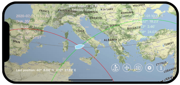
The "Circle of Position Navigation" app calculates the location directly from the intersection of two overlapping circles of altitude. The app's function is based on the Gauss method. It works with the altitudes of the sun.
The sun cannot be confused with any other star and is therefore a reliable navigation star. Stars have to be identified, which requires experience. Stars can only be used to determine your position at twilight because the horizon is usually not clear enough to see at night. This would only ever be a short time during which you would have to orientate yourself quickly. The moon is also not always visible during the day. At night, it is even completely invisible, as its light raises the sky optically, making it impossible to observe the stars. In a navigation app that has to be usable ad hoc, the sun is therefore the only rational navigation star.
In the app settings, a latitude north or south of the declination is used to specify which of the possible intersections should be calculated as the location. Further information relates to the use of sextants and index correction.
A test mode can be activated in the settings. This is a completely separate second system with its own basic settings. It runs independently and in parallel to a currently running navigation. The test mode can also be used to test the behaviour of any input.
The "Observations" menu, which consists of two blocks for a first and any number of second observations, is used for navigation. Only the time of an observation and the angle read on the sextant need to be entered in each block.
You can choose between Circle of Position and Noon Latitude. This means that it is also possible to determine the position using the noon latitude. The sextant is loaded automatically. A nautical yearbook is not required.
The Dead Reckoning module allows you to record the distance sailed in the time between observations. The current course and speed data should therefore be entered after every tack, gybe or sustained speed or course correction. If necessary and known, sea currents can also be taken into account.
A map module enables online downloading of the maps of the intended sailing area in higher resolution. These charts are then available offline. The graphic emphasises the essence of astro-navigation by also showing the altitude circles. All lines in the chart have a specific meaning, which is indicated by colour and shape.
The true Gauss method has not been handed down in nautical literature. We therefore take a brief look at its history:
In the 16th century, Tycho Brahe, a Danish astronomer, used a method with which he was able to deduce the position of an unknown star from the positions of two known stars. The same constellation also exists if the zenith of an unknown ship's position could be derived from the positions of two known celestial bodies. After all, the positions of the zenith on the celestial sphere and the image point on the earth are identical projections.
This led to the search for a mathematically simple solution to the so-called two-height problem. Famous mathematicians and scientists such as Leonhard Euler and Daniel Bernoulli took part in the search. However, maths was not part of a sailor's trade at the time and so it was not possible to find a practicable, seaworthy solution.
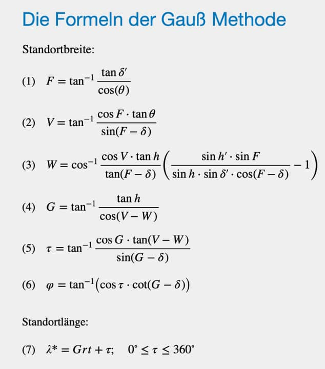
The search for possible solutions became an intellectual challenge. While numerous authors, avoiding spherical trigonometry, were looking for methods to calculate the width ϕ from other elements of a known graphical model, Carl Friedrich Gauss took a completely different approach. He used an abstract model instead of a visual one. This was a system of equations that clearly described the drawing.

In this system of equations, the latitude ϕ and the hour angle τ are the unknowns to be calculated. Its resolution from 1808 consisted of six clear formulae that would even have enabled a direct logarithmic calculation.
The formulas are optimised in their application. It is not necessary to take into account whether the heights were observed in the morning or afternoon or whether the observation times go beyond a current date.
According to current understanding, the intermediate time of the observations given in degrees is 𝜃 = Grt' - Grt. The southern intersection point Y of the altitude circles is calculated by using W as a negative value.
The site longitude is the sum of τ and the Greenwich angle Grt and only needs to be divided into westerly longitudes (-λ*) and easterly longitudes (360° - λ*).
The Gauss method is ideal for digitisation. No location estimation is required, there is no height limit and the result is mathematically exact.
However, the solution formulae were much more abstract than the formula approach and nobody was able to derive an idea from them. Gauss was far too far ahead of his time. Gauss also calculated the hour angle τ, which, when added to the star angle, gave the time from which the longitude could be determined.
However, this calculated time is derived from the observation times. It is therefore not the case that the Gauss method can also be used to determine longitude without a chronometer.
The formulas are optimised in their application. It is not necessary to take into account whether the heights were observed in the morning or afternoon or whether the observation times go beyond a current date.
According to current understanding, the intermediate time of the observations given in degrees is 𝜃 = Grt' - Grt. The southern intersection point Y of the altitude circles is calculated by using W as a negative value.
The site longitude is the sum of τ and the Greenwich angle Grt and only needs to be divided into westerly longitudes (-λ*) and easterly longitudes (360° - λ*).
The Gauss method is ideal for digitisation. No location estimation is required, there is no height limit and the result is mathematically exact.

