

by Johanna Henriksson
On a cool morning, a light breeze blows in a sheltered bay on Torö in the southern Stockholm archipelago. A small ferry hums incessantly towards Landsort, a lighthouse island inhabited all year round. Beyond it, serene silence reigns. While the beauty of the Stockholm archipelago pleases the eye above the waterline, sensitive biological treasures lie beneath the sea surface. One of these is a seagrass meadow hidden beneath the gentle lapping of the waves in Torö Bay: a shimmering green world where large pipefish and broadnose pipefish, relatives of the seahorse, frolic among the strands of seagrass.
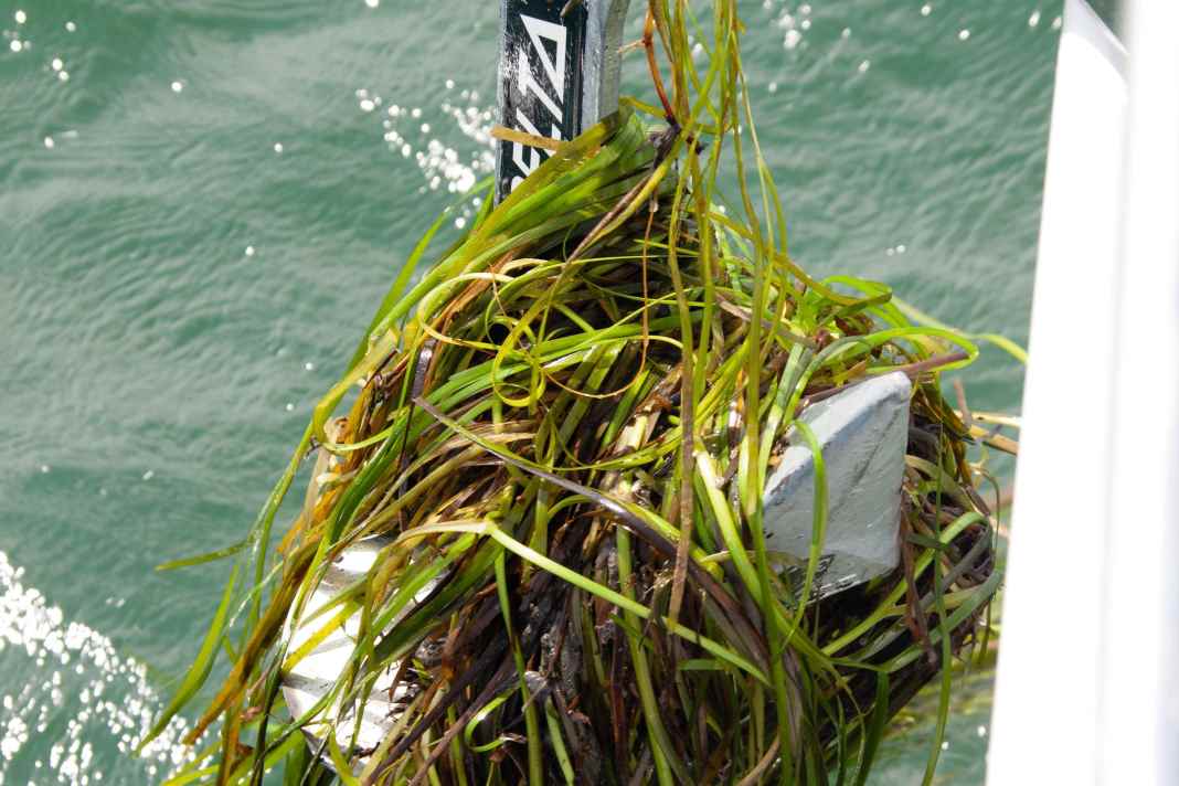
"It's incredibly beautiful down there," says Sofia Wikström, a marine ecologist at Stockholm University's Baltic Sea Centre. She kneels on the jetty to collect stalks of seagrass floating on the surface that have come loose from the seabed.
Stockholm archipelago nursery
The Stockholm archipelago is dotted with shallow, sensitive bays and coastal strips like this one. They are often referred to as the nursery of the Baltic Sea, as they harbour the vegetation that provides the habitat for spawning fish such as pike and perch, as well as a variety of invertebrates. Careless boaters can unintentionally damage these ecosystems.
"Studies from other parts of the world, for example from the Mediterranean region or the coasts of the USA, show that seagrass is significantly jeopardised by recreational boats. Their anchors and the turbulence caused by the propellers leave permanent scars on the seabed. This prompted us to investigate whether the same problems occur in the Baltic Sea," reports Wikström.
How the seaweed is damaged
Research shows that bays that are naturally sheltered from waves are particularly vulnerable. Such ecosystems are poorly equipped to cope with the turbulence caused by boats, especially in shallow areas with a depth of less than two metres. The flora and fauna there are less well adapted to strong water movements. The waves generated by boats stir up the fine sediment, causing the water to become cloudy. Less sunlight then reaches the plants, limiting their photosynthesis. Ship propellers and anchors in particular can also uproot aquatic plants. Or they are buried under the previously stirred up sediment when it settles back to the bottom.
Tip: Here you will find a large Anchor Guide with everything there is to know about dropping the basic iron.
Seagrass grows slowly and anchors itself in the sediment with its roots," adds Wikström. "If a meadow is damaged, the seabed can erode, leading to further damage. Here in this part of the Baltic Sea, seagrass is at the edge of its range and has difficulty reproducing sexually; instead, it relies on vegetative growth. Once a meadow has disappeared, it can take decades for it to recover - if at all," explains the scientist. Other species, such as slow-growing stoneworts and small pond grasses, are also under threat.
"It's obvious that you should behave carefully if you know that you could otherwise harm nature. After all, we wouldn't drive our car right across a flowering meadow. We see the damage, such as deep tyre marks, and avoid it. The same logic should apply at sea. The problem is that we don't see what's going on underwater. We don't realise what tracks we leave on the seabed," says Wikström.
However, there are ways to minimise the impact of boating: Care should be taken when entering shallow bays. Sailboats, with their smaller engines and lower speed, are less problematic than motorboats. Sailors should therefore choose their anchorage carefully.
An app shows where to find seaweed
The initiative in the Stockholm archipelago is an example of how scientific data can be practically applied to promote environmental awareness and the conservation of marine ecosystems. Sofia Wikström and her colleagues at Stockholm University have mapped hundreds of underwater areas in co-operation with the county administration. After collecting a huge amount of site data, they contacted the Swedish Pleasure Craft Association. Together they looked for a way to protect the bays. The discussions revealed that many boaters lack information about sensitive areas, which makes environmentally conscious decisions difficult.

Special digital overlays were therefore created in collaboration with a leading Swedish developer of nautical chart apps. Areas worthy of protection in a bay can now be superimposed on the conventional navigation chart. Sailors approaching a marked area are prompted to click on Details on the chart. They can then see which plants cover the seabed that need to be protected. There are also instructions on how to enter the area in question by boat. The overlays contain guidelines, such as keeping a low speed or steering as straight a course as possible to avoid stirring up sediment. Or anchoring at certain depths where no plants are damaged.
This integration of biotope information into the instruments that boat owners use per se is intended to protect the seabed at a specific location. In addition, the crews are informed about the environments in which sensitive habitats occur.
"A ban would be difficult to enforce. How can you monitor that no one is travelling into a remote little bay? Providing information, on the other hand, allows boaters to make informed decisions themselves. It also raises sailors' awareness so that they can recognise similar vulnerable areas even in unmarked areas," hopes Sofia Wikström.
According to the scientist, there are no anchoring bans in Swedish waters for environmental reasons. The inclusion of sensitive habitats on nautical charts is therefore a significant step forward for nature conservation. Bird and seal sanctuaries have long been included on nautical charts, but marine protected areas have not.
The app is already helping
The map service, which was introduced last spring, can be used free of charge. Initial feedback has been very positive, says Sofia Wikström. Even though the long-term results are still uncertain, according to the app developer Skippo, 70 per cent of users surveyed find the information about sensitive underwater areas valuable or very valuable. "Nobody I've spoken to has found the additional information in the map app annoying. Many people ultimately want to do the right thing," says Sofia Wikström.
One of these users is the sailor Anton Kalland, who fondly remembers the summers of his childhood when he explored the Finnish coast in a small wooden boat. Today, he and his family live in Stockholm and take every opportunity to go out into the archipelago on their Artekno H 35. Kalland regularly uses environmental information to navigate responsibly.

I want to anchor without damaging the seabed. The charts help me to recognise sensitive areas." Anton Kalland
His new awareness of the underwater world has influenced the family's choice of sailing routes. "If a bay looks interesting but sensitive according to the environmental data, we choose the anchorage with particular care. It has happened several times that we have anchored in a different place than we had originally planned. Maybe it's still the same bay, but on the outer edge and not further in. And we weigh anchor as vertically as possible to prevent it from ploughing up the seabed when we pick it up."
However, Kalland notes that most boaters don't know about the new chart information. "Some aren't interested in it, but I think more people would use it if they knew about it," he says. He also envisions expanded features, such as real-time data on algal blooms, pollution levels, more information on local animal and plant species, or even just tips on where you're most likely to see seals, for example. "Apps for forests show you local mushroom species and historical artefacts. Why not something similar for the sea?" he suggests.
The app data is to be expanded
The nautical chart project currently covers around one hundred locations in the Stockholm archipelago. More are to be added. The aim is to map the entire Swedish coastline. The researchers want to proceed selectively and only mark the most valuable ecosystems. "We need to focus on bays that we are sure are important and in need of protection. We can't designate every bay or natural harbour in the Stockholm archipelago as particularly sensitive. And we don't need to include places that the boat owners themselves know are not particularly worthy of protection. Such over-labelling would undermine confidence in the project and dilute our message," explains Sofia Wikström.
The next steps include publishing the so-called GIS data as open source to enable wider use. Wikström can imagine the Swedish Maritime Administration taking over the project at some point and expanding it. "The authority is responsible for creating nautical chart data for the whole of Sweden. So if we want a national framework, it would make sense for the responsibility to lie with the national authority. However, this would require political support," she says.
Wikström believes that this approach could even promote international cooperation. "There have long been pan-European mapping projects that compile map data from all European seas. If the EU Commission considers this important enough, it could have environmental data included in these works. However, this has not yet been discussed," she says.
Role model for Germany
Martin Wahl, marine ecologist at the Geomar Helmholtz Centre for Ocean Research in Kiel, agrees that seagrass beds are an important issue. He knows the Stockholm archipelago and praises its beauty. And he thinks it is promising to take similar initiatives in Germany. There are extensive and detailed maps showing the distribution of seagrass meadows along the German coast. However, they are not integrated into the existing nautical charts that sailors use for navigation.

We need to talk to each other more." Martin Wahl
"The interaction between scientists and society at large could be greatly improved in Germany. Our research focuses on publications and not on practical applications," he criticises. "But I would be confident that sailors would use the environmental data if we made it available to them. Most of the damage is caused by ignorance, not ill will," says Martin Wahl.
He admits that it is a challenge to harmonise the interests of nature conservation and recreational boating. In Germany, the planned Baltic Sea National Park met with fierce resistance from motor boaters, sailors and fishermen, which led to its cancellation. It's a complex issue," says Wahl. And that sailors are often more environmentally aware than motor boaters, as they are dependent on natural elements such as wind and tides. "I would say that all sailors experience that there is something stronger than themselves. That's why they respect the environment above water," says Wahl. "Few know what's underwater, but they are open to learning."
Both Sofia Wikström and Martin Wahl emphasise that recreational boating is not the biggest threat to the Baltic Sea. Problems such as over-fertilisation by agriculture and industrial fishing are more serious.
However, Wikström emphasises the importance of individual measures: "We need to combat industrial fishing and further reduce nutrient inputs from agriculture. These are large-scale measures that have to be decided far away, for example in Brussels. On the other hand, every individual can do something locally, for example by using our environmental maps and exercising appropriate caution in sensitive bays. This is an opportunity to protect our habitat ourselves.
6 behavioural tips
Sensitive bays are often naturally sheltered from the waves, with narrow or multiple entrances, sometimes with an island to keep the waves out. If it is wavy outside the bay but glassy inside, it is probably a sensitive area.
- Enter slowly and avoid excessive manoeuvres with your boat.
- Avoid anchoring in seagrass beds.
- Use a mooring buoy if one is available.
- When anchoring, choose deep areas. The seaweed in the Stockholm archipelago grows at depths of no more than nine metres.
- Do not drag the anchor across the seabed when hoisting. Pick it up as vertically as possible.
- Do not discharge any waste water into bodies of water. This harms the environment and is also prohibited.

