Territory: Gibraltar - a historic stopover between the Mediterranean and the Atlantic
Christian Tiedt
· 24.11.2024


/the-bay-of-algeciras-with-the-centre-of-gibraltar-in-the-foreground)


The Pillars of Heracles: They have their origins deep in the myths of ancient Greece. According to legend, Heracles, son of Zeus, created them at the entrance to the Strait of Gibraltar to mark the boundary between the known world and the unknown. According to legend, the famous hero attached signs to the pillars with an inscription: "Non plus ultra" - nothing comes after this. A clear warning to sailors not to venture into the unexplored expanses of the Atlantic, with its long swells and dark horizon.
Gibraltar is the gateway to the Atlantic
Unsurprisingly today, no one has ever seen these tablets. However, as not even a single stone of the actual pillars was ever discovered, scholars soon identified two highly visible, towering geographical features with them: One was the prominent Rock of Gibraltar on the European side and the other was the Jbel Musa mountain range on the African side, which is now part of Morocco.
Throughout history, the mountains themselves have become a symbol of discovery and adventure. Ancient and Renaissance seafarers saw the Strait of Gibraltar as a gateway. Not as the end of a journey, but as the beginning. For their robust caravels and carracks, it symbolised a farewell to the familiar: the last exit to Europe.
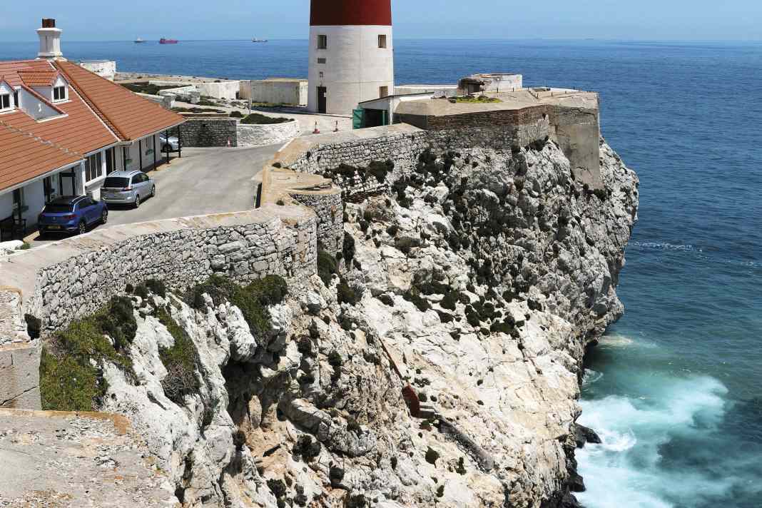
The name of the southernmost tip of the Gibraltar peninsula is therefore apt: Europa Point. Its striking lighthouse, gleaming white with a red band, rises on high cliffs at the foot of the rock. It is an important landmark and sea mark for all skippers travelling between the seas who want to break their journey in the wide bay of Algeciras and the harbours of Gibraltar. The tower was built in the time of Queen Victoria and is still operated by Trinity House, the lighthouse authority in London.
Gibraltar held a key position for the British
Gibraltar is a British overseas territory with limited internal autonomy and strong ties to the United Kingdom. Conquered in 1704 and officially handed over from Spain to Great Britain in 1713 with the Peace of Utrecht, the territory, which is barely seven square kilometres in size (roughly equivalent to the area of the Hamburg suburb of Blankenese on the Elbe), is by far the smallest of its kind.
However, the strategic importance of Gibraltar as the guardian of the Strait of Gibraltar, an important sea route between the Atlantic and the Mediterranean, was all the greater: the spoils of war became a key position of inestimable value for the maritime power of the Royal Navy and later for the Empire's secure trade routes. To emphasise this role, this key has even featured on the official flag of Gibraltar since 1982.
The actual transition to the Atlantic lies further west
However, the limestone rock, which towers far above the surrounding countryside, has long since given up its military inaccessibility and is instead conquered by hordes of tourists every day. Visitors can take the Gibraltar Cable Car to the summit at a height of 426 metres. The colony of around 200 wild
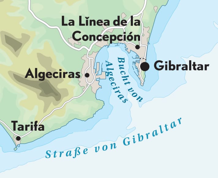
Barbary apes that live on the rock are another attraction. But be careful: carry rucksacks and bags at the front, the "landlords" like to help themselves. The panoramic view from the viewing platform and various other vantage points is breathtaking. On a clear day, the coast of Morocco, around eleven nautical miles away, is clearly visible. The southernmost point of the European mainland and the actual transition to the Atlantic, the Spanish town of Tarifa, lies to the west. This is also where the Strait of Gibraltar reaches its narrowest point at eight nautical miles wide.
100,000 transits a year make the Strait of Gibraltar one of the busiest shipping lanes in the world

British flair in the Mediterranean
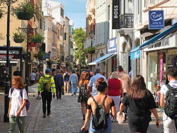
British flair is still omnipresent in Gibraltar. One place where visitors can experience particularly strong influences from the home island is Grand Casemates Square. This lively square in the historic centre of Gibraltar, right at the foot of the Rock, is lined with pubs, cafés and restaurants where fish and chips, one pint of bitter or a cuppa tea served on the counter or at the table.
One of the most famous pubs in the adjoining Main Street, alongside the Angry Friar, is of course the Lord Nelson. It is named after the naval hero who won his greatest victory in 1805 against Napoleon's combined fleet of French and Spanish ships of the line at Cape Trafalgar, just a short distance away - but who also lost his life on the deck of his flagship "Victory".

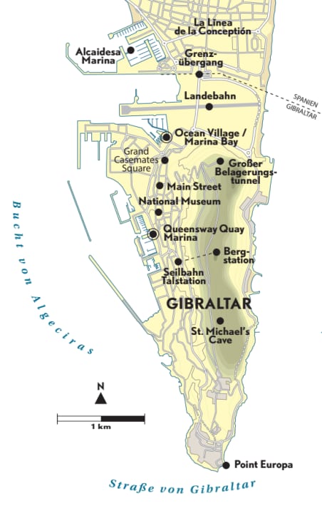
The red telephone boxes and postboxes are also very British. In addition, the architectural style and names such as Queensway Road and Winston Churchill Avenue are reminiscent of the distant mother country. Other items on the bucket list for a visit to "Gib", as it is shortened, include the Great Siege Tunnel from the 18th century, St Michael's Cave, a stalactite cave that is also used for concerts, the Gibraltar National Museum in Bomb House Lane and the nature reserve on the upper slopes of the Rock with its diverse Mediterranean flora and fauna.
Area information Gibraltar

Incidentally, citizens of the European Union can enter Gibraltar with a valid passport, but must observe the customs and entry regulations, as Gibraltar is not part of the Schengen area and carries out its own controls. Guests travelling on their own keel must clear in at one of the marinas on arrival. At the harbour office (pier master) an electronic customs declaration system is available to skippers for this purpose.
Marinas in Gibraltar
There are only marinas on the western side of the peninsula, i.e. within the Bay of Gibraltar. There are two marinas to choose from: Ocean Village/Marina Bay just south of the international airport runway (registration and berth allocation via VHF channel 71, full service in the marina including petrol station, oceanvillage.gi). Caution: No entry or exit is permitted during flight operations and warning lights. Anchoring is also prohibited due to the height restriction (observe the nautical chart).
The other option is the centrally located, exclusive Queensway Quay Marina, also with a full range of services (registration also via UKW-71, queenswayquay.com). Both harbours are also designed for mega yachts; regular-sized yachts usually moor with mooring lines at the bow and stern to the jetty, as is usual in the Mediterranean.
Marina alternative on the Spanish side
Alternatively, the Alcaidesa Marina can also be approached. Its large basin is located directly north of the runway on the Spanish side of the border in the neighbouring village of La Línea de la Concepción (alcaidesamarina.com). From here you can also enter Gibraltar on foot. There is a bus stop directly behind the border crossing. The Spanish town of Tarifa is around 14 nautical miles away. The nearest marina on the eastern side is Sotogrande, around eleven nautical miles away. It is around 32 nautical miles to Marbella on a direct north-easterly course from Europa Point and around 60 nautical miles to Málaga.
Nautical information about the Strait of Gibraltar
When passing through the Strait of Gibraltar, in addition to the tidal currents, the surface current should also be taken into account, which constantly moves from west to east at one to two knots. The same may apply to the almost 22 nautical mile-long traffic separation scheme, which guides maritime traffic between the Mediterranean and Atlantic in an orderly fashion - even if sports skippers will mostly be travelling in the northern coastal traffic zone on the Spanish side. 100,000 transits a year, from yachts to supertankers, make the strait one of the busiest shipping lanes in the world. "Non plus ultra" - that was once upon a time.

