Funen: Twelve bays for perfect nights at anchor in the Great and Little Belt


- 1 Thurøbund
- 2 Lunkebugten
- 3 Revkrog
- 4 Lyø
- 5 Vemmingbund
- 6 Dyvig
- 7 Kalvø
- 8 Helnæs Bugt
- 9 Torø
- 10 Gamborg Fjord
- 11 Korshavn
- 12 Æbelø
1 Thurøbund
Where the schooners once spent the winter
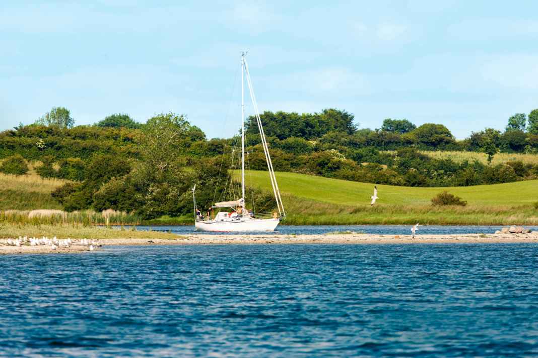
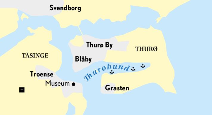
In the very south of Funen and north-east of the island of Tåsinge lies the former winter harbour on Thurø. Hundreds of wooden sailing cargo ships once survived the frosty season here. It was only when transport routes shifted to the roads that the harbour lost its importance for shipowners. Small boatyards can still be found here today, and pleasure boaters have now discovered the protected natural harbour for themselves. They not only enjoy the surrounding landscape. The immediate proximity to the historic seafaring towns of Svendborg and Troense also make this anchorage attractive.
Shore leave: It is possible to land with the dinghy at the surrounding club or boatyard jetties. Or you can head straight across Svendborgsund to Troense. A stroll through the old alleyways of the seafaring settlement is worthwhile, as is a visit to the maritime museum. From here, the 250 bus takes you to Svendborg in 15 minutes for shopping or to the railway station for the crew transfer.
Navigation: The approach is only recommended in daylight. Pass the western mark south of Blåby and then enter the bay north of Kidholm. Except in westerly winds, you are very sheltered here behind the wooded Grasten peninsula. Depths in the northern area are around four and a half metres, further east three metres. Anchoring ground partly weedy.
Also interesting:
2 Lunkebugten
In the shadow of Valdemar Castle
Just three miles south of Thurøbund is the large Lunke Bay, which is open to the north. This is a good place to spend the night if you want to sail through Svendborgsund or towards the Belt in daylight the next day. As you approach the bay, Valdemar Castle on the island of Tåsinge is a magnificent landmark. It was built in 1644 and designed in the classical Renaissance style with extensive gardens and parks. Unfortunately, it is currently not possible to visit.
Shore leave: There are marvellous walks on Tåsinge. Or the crew can take the historic ferry "M/S Helge" from the castle pier to Svendborg. The tower of Bregninge church, just under four kilometres away, guarantees far-reaching views: from the top, you can look out over the South Fyn archipelago and the town of Svendborg.
Navigation: Even if it looks nice and offers good cover: Don't anchor too close to land at Valdemar Castle; it gets very shallow there. There is deeper water and equally good shelter behind Nørreskov, where trees keep out the wind. Alternatively, you can drop anchor east of the Stenodden peninsula. There it digs into the loamy bottom under the weeds.
3 Revkrog
Plenty of space in front of colourful bathhouses
The island of Ærø has a lot to offer, and the large open bay to the west of the main town of Ærøskøbing is perfect for relaxed anchoring in a beautiful landscape. The long beach, a small cliff and colourful bathing houses on the shore make you want to go ashore. Simply take the dinghy across to the campsite.
Shore leave: From the campsite it is only a one kilometre walk to the beautiful centre of Ærøskøbing (photo). There you will find art galleries, restaurants, cafés and a supermarket. You can get to all other island towns free of charge by bus.
Navigation: You can easily enter the large bay with water depths of up to eleven metres. Anchoring is generally possible anywhere between four and seven metres on a mostly sandy bottom. Stones in places. The east side of the bay near the campsite is popular. Good protection except in north-westerly winds. In westerly winds, it is best to anchor close inshore behind Borgnæs Nakke, the two-metre line runs close to the shore.
4 Lyø
Small island with a large fan base
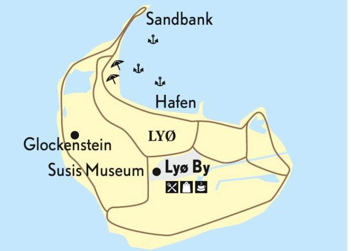
Diverse nature, beautiful beaches and willow-lined paths make the island a jewel in the Danish South Sea. The peaceful village of Lyø By, about two kilometres from the harbour, delights visitors with its well-preserved half-timbered houses, pretty flower gardens and old fruit trees. Gourmets can stock up on fresh produce in the country shop or try out the regional cuisine.
Shore leave: Take the dinghy into the harbour or to the shallow shore. From there to the village, where there is a small grocery shop with a beer garden. Small snacks are available in the "Oasis" to the north-west of the campsite and in "Café No. 7". This can be found in the village centre near the church. All sorts of curiosities, including shrunken heads, are on display in Susi's Skrøne Museum. A walk leads to the Glockenstein, an ancient dolmen stone from the sandbank 3,500 BC, or you can hike around Lyø and Lyø Rev, taking note of the quiet times in the bird sanctuary.
Navigation: Directly to the west of the harbour is a beautiful roadstead with a water depth of two to five metres. Sandy bottom, partly weedy. Leeward protection from north-westerly to southerly winds.
5 Vemmingbund
The breath of history
There is plenty of space in the western part of Sønderborg Bay. There is also a great view of the Düppel Redoubt with the historic mill, where history was made during the Prussian-Danish War.
Shore leave: The shallow water on the beach in the village of Vemmingbund is ideal for children to play in and can be reached by dinghy. The "Vemmingbund Café & Restaurant" is also located here. You can buy groceries at the mini-market on the campsite. If you walk three kilometres north through fields and meadows, you will reach Dybbøl Sogn, where it is worth visiting the Dybbøl Banke history centre with its impressive exhibition on the events of the war around 1864. There is also a supermarket in the village. South of the Dynt Hoved peninsula, you can hike through a marvellous area with magnificent views over the fjord and the Bay of Geltingen.
Navigation: The bay is 20 metres deep in the middle and the two-metre line extends just under land. Anchor in northerly winds either in the northern area directly in front of the Düppeler Schanze. Or in westerly and south-westerly winds, well protected off Dynt Hoved. The bottom is predominantly sandy.
6 Dyvig
Safe as in Abraham's bosom
The beautifully scenic waters of Dyvig and Mjels Vig are an anchoring hotspot in summer. Then it is often crowded and less relaxing here. The development of the local marinas has also been extended, which helps the infrastructure but detracts from the experience of nature. Things are quieter on weekdays and in the low season.
Shore leave: With the dinghy to the marina. Stock up on provisions in the local mini shop. Or take the free bus to Nordborg. The Universe technology and science adventure park there is interesting for young and old. The "Dyvig Badehotel" has a bathing island and a playground on the south shore. There is also a brasserie with snacks and a gourmet restaurant with sophisticated menus.
Navigation: Enter in daylight through the narrow, three metre deep dredged channel of Stegløb. Then drop anchor in the south-western or northern part of the bay at a depth of two to four metres. Or continue through the narrows to Mjels Vig and anchor there at a depth of two to three metres. The bottom is muddy, check the hold of the anchor. Wind protection from all directions. In westerly to north-westerly gales, the water level can drop by one metre.
7 Kalvø
Island location in a deep bay
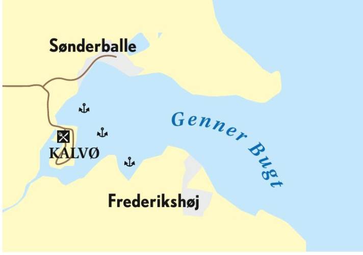
Genner Vik is the rear part of a deep bay. The island of Barsø lies to the east, protecting the entrance like a cork pulled out of a bottle. Far inland is the small island of Kalvø. It is connected to the mainland by a causeway and was once the site of Denmark's second largest shipyard. Today, Viking ships are built here and museum projects are organised.
Shore leave: The surrounding area is a bird sanctuary and marked hiking trails invite you to go for a walk. The "Kalvø Badehotel and Restaurant" will be offering lunch and dinner again this season. Crews can also buy some groceries here. The campsite also has a small shop.
Navigation: Deep bay with very good anchoring possibilities in water depths of three to ten metres. Sandy bottom, partly herbaceous. Very sheltered except in easterly and south-easterly winds. The south side of the fjord with Nørreskov in particular offers good leeward cover. The bottom there is muddy, so the anchor should be checked.
8 Helnæs Bugt
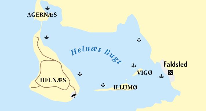
In the realm of the Vikings
The sailing Norsemen had already chosen the bay as a harbour and trading centre. It is protected by the Helnæs and Agernæs peninsulas and the island of Illumø. There are numerous good anchorages behind them.
Shore leave: The Øhavsstien, a hiking trail with long stretches through the South Fyn Archipelago, starts at Faldsled harbour. There are also beaches for swimming and calm shallow water for SUP paddling. If you anchor on the east side of the bay and have a well-stocked on-board cash box, you can head to the gourmet restaurant "Falsled Kro" for a sumptuous meal and drink. For a handful of crowns, you can get burgers, ice cream and more at the village snack bar "Vandkanten".
Navigation: When entering the bay, it is important to catch the buoyed passage. The shallowest depth is around 2.3 metres. Behind this, a wide bay opens up with lee shores for all wind directions and water depths of between two and five metres. Predominantly sandy bottom. The islets of Illumø, Horsehoved and Vigø also offer protection from southerly winds.
9 Torø
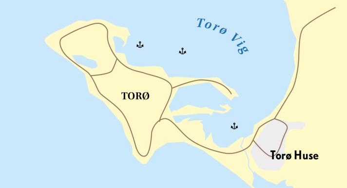
Caribbean flair in the Little Belt
Torø Vig lies to the south of Assens. The bay is protected to the south-south-west by the former island, which became a peninsula as a result of silting up, and by a sandbank that extends far into the Belt. Forests, meadows and beaches invite you to linger. Torø is only inhabited in summer, when it serves as a holiday camp for children.
Shore leave: If anything is hygge, cosy, then this is it: The picturesque fishing village of Torø Huse is definitely worth a visit. Things are livelier in Assens, three kilometres away, which can be reached by on-board bike or public bus. There are numerous restaurants and shops in the small town. Torø has many walking paths and beaches with shallow water in the bay - ideal for family crews.
Navigation: Enter the natural harbour from the north-west and keep clear of Torø Rev, which juts far out into the Belt. Anchor on a sandy bottom at a depth of three to five metres. The two-metre line runs close to the shore. With a shallow draught, it is possible to enter the harbour as far as Torø Huse, keeping close to the sandbank. Fishing boats (photo right) and some local yachts are moored there. Anchor on the herbaceous ground or tie up to the dolphins there. But beware, the water depths of four metres shown on the nautical charts should be treated with caution, as the bay tends to silt up!
10 Gamborg Fjord
Inland feeling on the Keinen Belt
If you are sailing into Fænøsund at the northern end of the Little Belt, it is best to steer hard to the south-east just after the long sandbank Fønsskov Odde. You will then reach a thoroughly sheltered stretch of water that is almost reminiscent of an inland lake.
Shore leave: Not spectacular, but a beautiful moraine landscape formed by the Ice Age with forest and meadows. Fønsskov Odde is accessible - and a favourite fishing spot. The island of Fænø or the Middelfart marina can be visited by SUP. Or you can take a detour to the small jetty at Svinø Bådelaug. Take the bus from Gamborg to Middelfart for shopping or a visit to a restaurant.
Navigation: Fænøsund is not lit at night, but is easy to navigate during the day. Good anchorages in southerly to westerly winds along the coast of the wooded Føns peninsula. In easterly winds, head to leeward of Svinø and anchor in Ellebæk Vig in depths of up to four metres. The bottom can be weedy, but is mostly muddy, and sandy further west. Water depths of up to twelve metres in the middle of the fjord; the two-metre line runs close to the western shore in places. A few rocks decorate the area, but these are all marked on the nautical chart.
11 Korshavn
Natural harbour in a class of its own
The outer tip of the Hindsholm peninsula is called Fynshoved. Here, too, the ice age has left its mark in the form of a moraine landscape. Sailors will find two shallow, very well protected lagoons here. The more northerly is Korshavn with a narrow entrance between the cliff and the shingle beach. Odense Sejlklub operates a small jetty with sanitary facilities here, which will be rebuilt after the October 2023 storm.
Shore leave: Take the dinghy to the jetty or the beach. Wonderful walks, preferably at sunset, in the hilly landscape with views of the islands of Endelave and Samsø. Groceries are available at the nearby campsite, or you can take the 481 bus to Kerteminde, a small town with lots of shops and restaurants.
Navigation: The approach looks more difficult than it actually is. Be aware of shallows, especially north of the entrance, do not take shortcuts, go slowly. Seaweed on the bottom can give incorrect feedback to the echo sounder. Protected from all wind directions, in strong westerly winds there is some swell in the bay. The bottom consists of clay, sand and seaweed. The number of anchorages with a depth of more than two metres is limited and the bay is not particularly large. Boats with less draught can anchor in the front part of the southern lagoon. Be careful, there are lots of stones and it quickly becomes shallow.
12 Æbelø
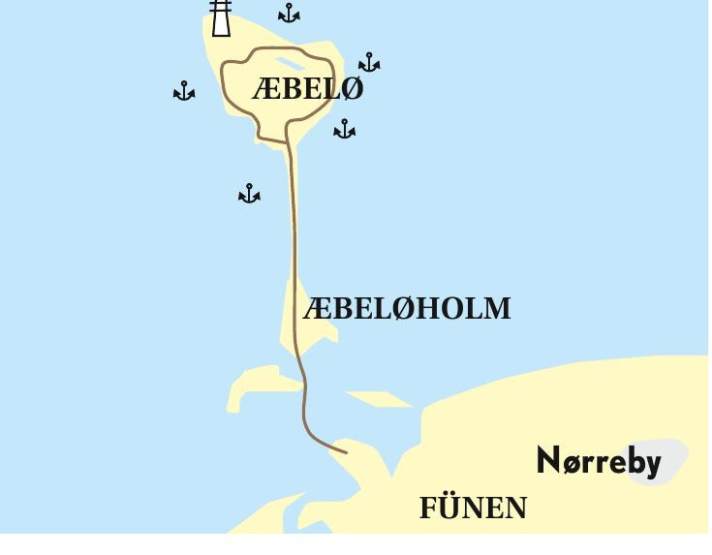
Hike through the mudflats
This former manor island, which was used as a hunting ground, is located on the north side of Funen. Even today there is a beautiful forest with ancient oaks that are under protection. You will look in vain for a harbour or a jetty, as people no longer live here. Instead, the island is home to deer, mouflons, impressive sea eagles and many other bird species. Seals like to frolic on the surrounding sands. The Swedish granite lighthouse from 1883 points the way into the Little Belt.
Shore leave: You can easily land with the dinghy. Watch out for stones! Beautiful walks and circular routes in the forest and on the beach. At low tide, you can walk to the mainland in about 45 minutes along a marked mudflat path, which is shown on the nautical chart.
Navigation: Anchoring under land. The eastern and western flanks are protected by forest and partly by a cliff. Care must be taken when approaching the northern coast, where there are some large rocks and reefs below the water surface. Sandy bottom, partly herb fields, occasional stones. The Dansk Sejlunion buoys are reserved for its members.

