Following a given chart course on the water can be quite a challenge. After all, boats don't always sail in a straight line.
The course loading described in the previous episode ensures that the bow points exactly in the direction of the destination. Nevertheless, the yacht can change course over ground if it is shifted sideways by wind and current.
In order to find out where this lateral offset is taking them and how it can be compensated for by holding ahead, the course charging must be extended. In the case of wind drift, this primarily requires experience, while nautical documentation helps to determine a tidal current offset.
Navigation series
Influence of wind
The wind-induced drift can often only be estimated. After all, it depends on many factors, such as the type of boat, the wind force, the current sails, the lateral plan, the heel and the correct trim.
Another factor is the course to the wind: while there is naturally hardly any lateral drift to be expected when sailing flat in front of the sheet, it is all the more noticeable on an upwind course.
Here, the sail profile generates an aerodynamic lift force that acts at right angles to the wind direction and laterally to the keel line. The fact that the boat still achieves forward propulsion is due to the underwater hull. The lateral plan counteracts lateral drift, while its design minimises drag. Nevertheless, there is always a certain transverse force at work, which, in addition to heeling, is noticeable in a drift through the water to leeward.
In short: the boat not only runs straight ahead, but also pushes through the water at an angle - what used to be called "dwars" - to the keel line.
Long-standing owners know from experience under which conditions their yacht is likely to drift. New owners and charterers are advised to constantly compare the target and actual course in order to be able to estimate and take drift into account.
Detailed drift tables or corresponding data sets are sometimes also created for racing yachts.
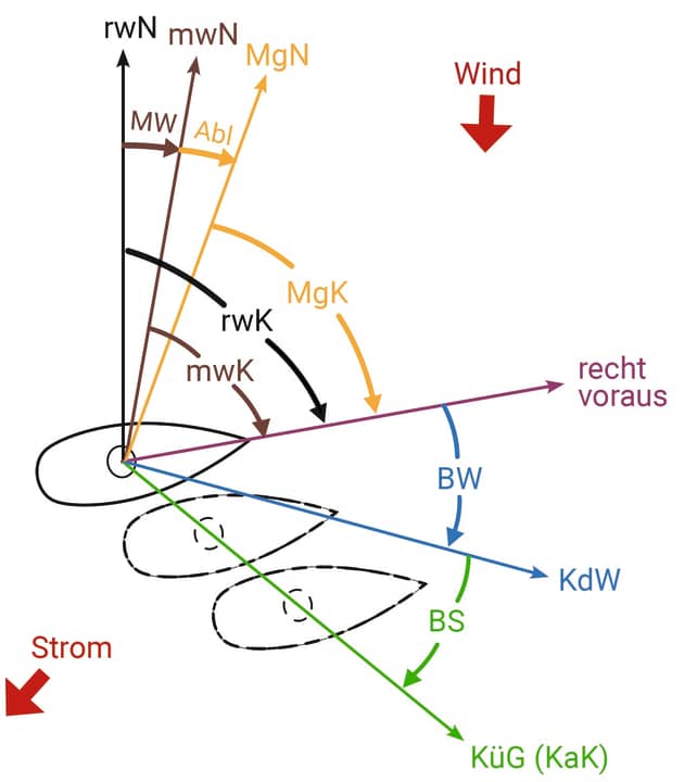
In order to take wind-induced drift into account during navigation, the course conversion scheme (see Figure 2) must be expanded to include an additional factor: the wind loading (BW). It describes the angle between the boat's right-ahead direction and its movement or course through the water (KdW):
MgK (magnetic compass heading) =
Abl (deflection) =
mwK (misdirection course) = MW (misdirection) =
rwK (right course) = BW (charging for wind) =
Course through the water (KdW) =
If we are sailing in the open sea and want to know where the drift is taking us, the heading (MgK) from top to bottom on the compass would have to be converted into a KdW.
In order to obtain a heading on which our yacht will steer straight through the water towards its destination, the course taken from the chart is used as KdW and the heading (MgK) is calculated from bottom to top (with reversed signs).
Whether the number of degrees used for the BW represents an empirical value or comes from a loading table, the following always applies: The BW always has a positive sign with wind from port (when the yacht is moved to starboard) and always a negative sign with wind from starboard.
Influence of flow
If there is also a current, the water itself also moves over the ground. Everything that floats in the water is also displaced. As a result, the movement of the yacht through the water no longer corresponds to its path over the ground, which means that an additional current feed (BS) is required. The BS describes the angular difference between the KdW and the course over ground (KüG), which corresponds to the chart course (KaK):
MgK (magnetic compass heading) = deflection =
mwK (misdirection course) = MW (misdirection) =
rwK (right course) = BW (charging for wind) =
Course through the water (KdW) = BS (charging for current) =
KüG (course over ground) =
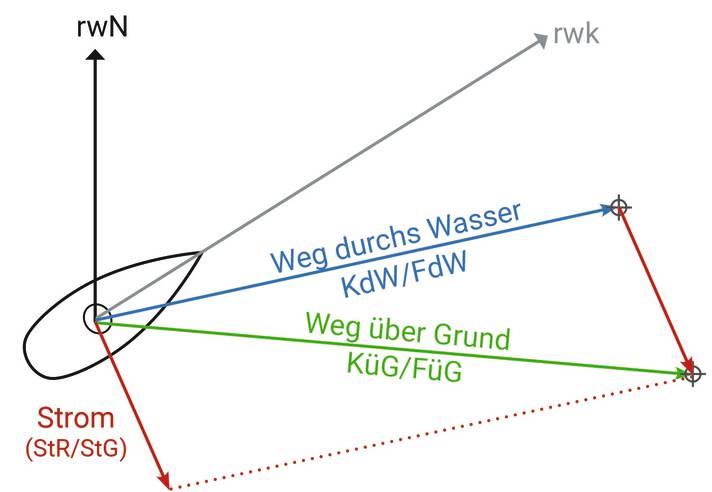
In the case of a surface current caused by wind, it may also be possible to work with a total feed for the offset - after all, BS and BW would then have the same cause (although not necessarily always the same effect).
The situation is different with tidal currents, whose direction and strength change continuously over the course of the tide. This requires a coordinated current feed, which requires reliable data on the prevailing tidal current.
Rich diamonds
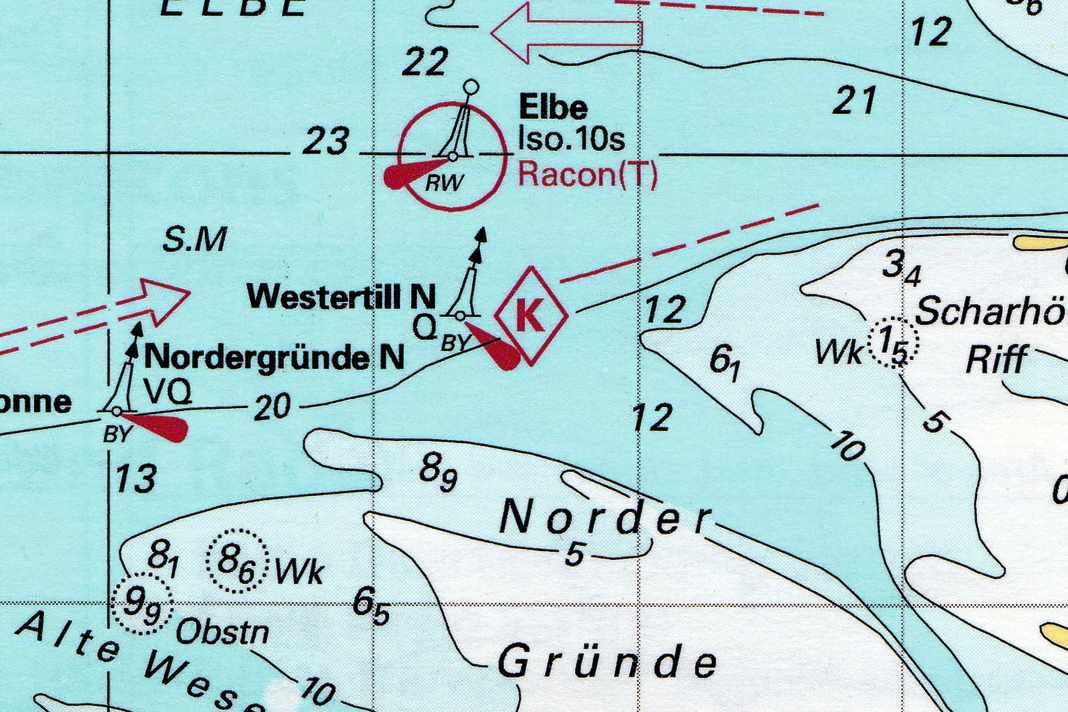
Information on the tidal current can be found in many sources - including nautical charts of tidal areas. These often show so-called current diamonds, which are labelled with letters. A tidal current table printed on the chart contains detailed information on the tidal current at the relevant position for each diamond. The current data is listed in hourly sequence - from six hours before to six hours after the high tide time at a reference location. The latter is indicated above the table.
A look at the tide calendar or the more detailed tide tables for the area (there are of course also smartphone apps for this) reveals when the high tide occurs at the reference point. If the high tide time at the reference location is known, we can enter the relevant line in the table - for example, two hours before high tide if we are at the Stromraute at 2 pm and the high tide at the reference location should occur at 4 pm (note: summer and winter time must be taken into account).


The age of the tide
In addition to a number of degrees for the direction of the current, there are two indications of the current speed in knots (kn) - one for spring time and one for neap time. Background: At spring time, the earth, moon and sun are in line (full and new moon), which further intensifies the tide-generating forces. This results in an increased tidal range, which is reflected in stronger tidal currents.
At neap tide, the sun is at right angles to the earth/moon axis, which results in a low tidal range and rather weak tidal currents. Midtide prevails between these phases - then the values for spring and neap tide should be interpolated.
This so-called age of the tide is also revealed by the tidal calendar. Caution: If you base your judgement solely on the phases of the moon, you may be making a misjudgement, as in some areas the topography causes the aforementioned effects to occur with a delay.
In the German Bight, for example, the so-called spring delay can amount to several days. The official German tidal calendar for the area contains a table on the age of the tide, which already takes the spring delay into account, whereas in other tide tables it is sometimes given individually for each reference location.
River atlases
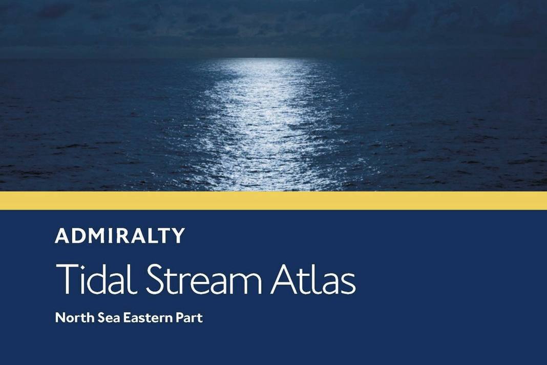


Current atlases are another source of tidal current information. They contain maps with current arrows that show the course of the current in a certain sea area at different times. Here, too, there are usually map sheets from six hours before to six hours after high tide at a reference location (in exceptional cases also with astronomical reference). There is also a longitude/latitude scale at the edge of the map to help you find the correct location.
A current atlas can be used to determine the tidal current at almost any location in the area shown, whereas current routes on nautical charts are often much further apart.
Browsing through a current atlas also gives you a clear impression of the tide in the area (compared to the bare figures in a current table). For example, you can estimate at a glance when would be the right time to complete a particular section of the route.
After all, in tidal areas it is important to sail as much distance as possible with the current flowing. An unfavourably setting current can prove to be extremely treacherous, especially in narrow places, such as in the straits, where it is amplified. It also becomes uncomfortable when the current sets against the prevailing wind direction, which results in heavy swell.
The direction of current is read out by applying a course triangle to the nearest current arrow. Current is always indicated in the direction in which it sets, which corresponds to the direction of the arrow. The current speed can be recognised by the length, shape and/or colour of the arrows, depending on the tidal unit.
In addition, there are figures for which attention must be paid to the unit of measurement. In the "Atlas of Tidal Currents for the North Sea" published by the Federal Maritime and Hydrographic Agency (BSH), the figures are given in knots - in older editions of the BSH work "Der küstennahe Gezeitenstrom in der Deutschen Bucht" in centimetres per second (cm/s, in the current edition also in knots).
In the British "Admiralty Tidal Stream Atlases", values are printed separated by commas. Here, one value applies to neap time and the other to spring time (both in tenths of a knot). "04.08" means 0.4 knots for neap time and 0.8 knots for spring time.
Some current atlases, on the other hand, only show the average tidal current conditions, so that corresponding surcharges must be applied at spring time (see the respective notes on use).
Current maps for the German North Sea and Baltic Sea coasts can also be viewed online on the BSH website (www.bsh.de, section "Data" and there under "Forecasts", "Currents").
Small drawing lesson
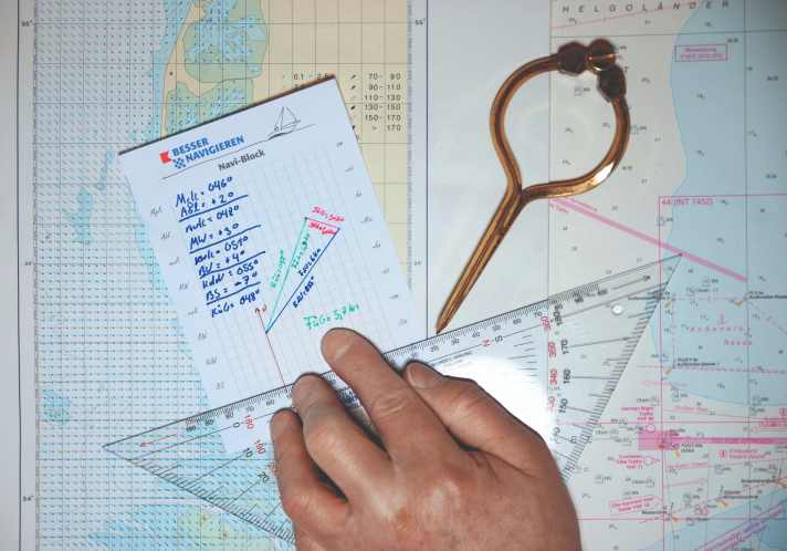
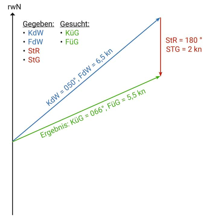
Vector addition by drawing a current triangle has proven useful for determining a course taking into account the determined current offset. A current triangle is made up of the following legs: the course through the water (KdW), the course over ground (KüG) and the current direction (StR).
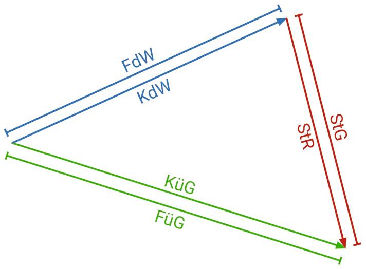
The length of the legs corresponds to the respective speed: the speed through the water (FdW) for the KdW, the speed over ground (FüG) for the KüG and the current speed (StG) for the StR.
The specific procedure depends on which leg of the triangle you are looking for: the KüG or the KdW. The StR and StG can be taken from the tidal current table or the current atlas. The FdW is either read from the log or used as an empirical value in view of the wind conditions to be expected on the route (wind force, course to the wind). The FüG, on the other hand, is always sought because it is also determined by the current that still has to be brought in.
First current task
Let's start by assuming that we have read the current heading (MgK) from the compass and now want to know where the prevailing current will take our yacht over ground.
After the MgK has been converted into a KdW, a vertical meridian is first drawn on a sheet as a north reference. The KdW is plotted from this meridian using the course triangle. Its length corresponds to the FdW read from the log.
When cutting the vectors to length, a uniform scale must be defined, for example one node per centimetre. The current vector is now drawn at the end of the KdW vector - in the direction of the StR and in the length of the StG.
Finally, the triangle is completed by drawing another leg from the starting point of the KdW on the meridian to the end of the current vector. This third vector corresponds to the KüG, its length to the FüG.
Second current task
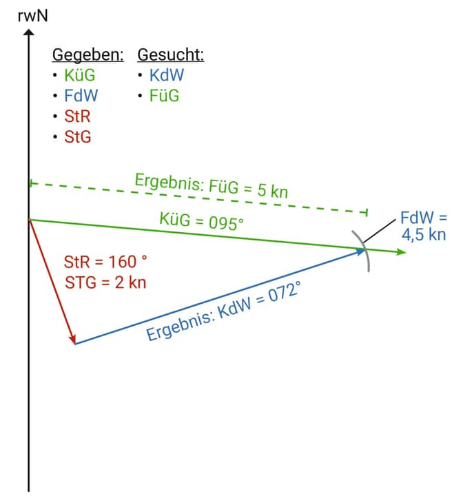
If a lead course is to be determined, the KüG taken from the map is first plotted on the meridian. This cannot yet be cut to length as the FüG is still unknown. This means that the current vector is plotted from the starting point of the KU.
What is still missing is the KdW leg, the length of which is known in the form of the FdW. Take this length in the compass and draw an arc around the end of the current vector that intersects the KdW.
Finally, the end of the current vector is connected to this intersection point. This third leg corresponds to the required KdW. At the same time, the intersection point on the KüG marks the length of the FüG, which can be used to calculate the estimated time of arrival (ETA).
Third current task
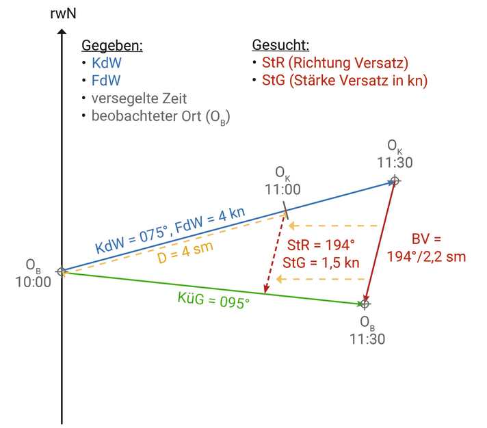
Finally, conscientious tidal current feeding can also help to determine wind drift and wind-induced surface currents. This is because if there is an offset between the mooring and the observed location despite the current feed, the wind can only be to blame. Either by pushing the boat sideways through the water and/or in the form of an unexpected wind-induced current.
If you are diligent in coupling (see episode 2), you can even determine this drift quite precisely using the so-called third current task - because the aforementioned cutlery displacement (BV) describes its direction and strength.
However, the distance of the offset only corresponds to the offset speed in knots if the BV refers to one hour. If the coupling interval is longer, the OK and OB must be "coupled back" to the positions after one hour, so to speak.
However, you can also simply construct an OK for the corresponding point in time on the coupling course and then move the BV parallel to this point. At the point of intersection with the KueG is then the recoupled OB for the same point in time.
In practice on board, however, you should not rely solely on the sources mentioned when taking the current into account, but always keep your eyes open for signs that could indicate a deviating offset.
For example, current turbulence and opposing tidal currents sometimes occur at bends and narrow points as well as in bays and in the area of harbour entrances, which set quite differently from the predicted tidal current. Wild water ripples and dancing buoys are evidence of this.
Electronic current data
Some navigation programmes and electronic nautical chart sets for plotters already include data on the tidal currents in the respective area. They can then be taken into account during electronic navigation. There are also various apps that can be used to retrieve current data if an internet connection is available. In addition, the Federal Maritime and Hydrographic Agency (BSH) offers data packages on surface currents in German coastal areas for download. These are data in Grib format, which can therefore only be used with compatible navigation or regatta software.
