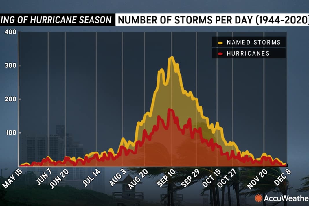


10 September is the so-called hurricane peak, i.e. the peak time for the Atlantic hurricane season. But very little has happened so far. However, water temperatures in the Gulf of Mexico have reached alarming highs, which drastically increases the risk of a rapid intensification of tropical storms and hurricanes in the coming weeks. According to AccuWeather-Experts believe that this is mainly due to the low level of tropical activity in the region so far. With the exception of the short-lived tropical storm Barry, which formed in the Bay of Campeche in June and made landfall in Mexico, the Gulf has been largely spared so far this hurricane season. The lack of storm movement has allowed water temperatures in the central and northern Gulf to rise to near record levels - a situation that could become particularly dangerous from mid-September.
Ideal conditions for rapid intensification
"Ocean heat content, or the depth of warm ocean water in the Gulf and western Caribbean, is near record levels," warns Alex DaSilva, senior hurricane expert at AccuWeather. Water temperatures in the Gulf are currently around 30 degrees Celsius, which could fuel a tropical storm. Compared to the previous year, when the hurricanes Beryl and Debby as well as tropical storms Alberto and Chris all passed through the Gulf before September, the region remained almost unaffected this year. These conditions would create a worrying scenario for the coming weeks.
The phenomenon of rapid intensification, in which sustained wind speeds increase by 58 mph (about 93 km/h) or more within 24 hours, has become more common in the Gulf in recent years. Devastating hurricanes Helene, Ian and Michael all intensified rapidly as they approached the coast. Hurricane Erin was the latest example of extreme rapid intensification in the Atlantic basin. Last month, Erin's maximum sustained winds increased by an astonishing 85 mph (about 137 km/h) in 24 hours, exploding the storm from a Category 1 hurricane to a Category 5 hurricane in the warm waters.
Increased risk for coastal regions
In the AccuWeather forecast for the 2025 Atlantic hurricane season, which was published back in March, the experts pointed to an increased risk of direct impacts along the Gulf Coast of Texas, Louisiana, Mississippi and Florida. Atlantic Canada, the coast of North Carolina, the north-eastern Caribbean, Puerto Rico and the US Virgin Islands are also at increased risk of direct storm impacts this season. The climatological peak of the Atlantic hurricane season falls on 10 September, and AccuWeather hurricane experts had already predicted in March that the second half of the season would have more named storms than the first half.
Up to 10 hurricanes expected
The AccuWeather forecast for the 2025 Atlantic hurricane season predicts 13 to 18 named storms, including seven to ten hurricanes and three to five major hurricanes that reach Category 3 or higher on the Saffir-Simpson Hurricane Wind Scale. A Category 3 hurricane has sustained winds between 111 and 129 mph (180 to 210 km/h). AccuWeather is forecasting three to six direct impacts on the U.S. this year, which is the range AccuWeather had predicted for the historic 2024 Atlantic hurricane season. AccuWeather hurricane experts issued an update in May urging people, businesses, government agencies and emergency responders to prepare for an increased risk of flooding and tornado impacts that could reach far inland, similar to last year.
"Atmospheric conditions are expected to be favourable for tropical development in late September," daSilva said. "We are concerned about the risk of rapid intensification if a storm forms later in the month or moves into the very warm waters of the Gulf."
The conditions are ready for an explosive, rapid intensification."

Lars Bolle
Chief Editor Digital

