

Nowadays, many pleasure craft have a GPS chart plotter with a digital nautical chart as their main means of navigation, which is unfortunately only considered an additional aid under the current legal situation. This form of electronic navigation has a considerable advantage over working with paper charts: Because the device automatically records the track on the electronic chart in the background, the skipper has more time to look out and guide the boat safely.
More on the topic:
In the event that the chart plotter fails, paper nautical charts must be kept on board as a backup according to the current legal situation. The legislator and also the German Sailing Association (DSV) are of the opinion that these - in addition to the official nautical charts, so-called non-official recreational craft charts are also permitted - must be updated to the latest version with the Notices to Mariners (NfS). However, shipping lawyers take a different view of the regulations. I will try to explain this and why the NfS are not suitable for updating non-official nautical charts below.
I have been on the water on my own keel for over 60 years. Starting on an optimist dinghy, followed by an OK dinghy and dinghy cruiser, right up to the listed 25-metre giekewer "Frieda". I financed my studies by sailing with young people with behavioural problems in youth sailing boats on the Elbe and Baltic Sea. Back then, we only had a compass on board and old nautical charts on which the starboard buoys were still labelled black, even though the A buoy system was already in place - with green to starboard.
Later, the trips with aviation charts shrink-wrapped in plastic were legendary, with which you could make beautiful trips to Bornholm with the radio direction finder - we always arrived. As I now mainly sail on the Baltic Sea, my charts, like those of many other experienced leisure sailors, are not regularly updated but replaced after around five years because they are worn out through use.
Just having a chart plotter on board is not enough
Nowadays, commercial shipping mainly uses electronic nautical charts on ECDIS systems (Electronic Chart Display and Information System) with approved hardware, software and the latest digital nautical chart data and other information. If official paper nautical charts are still on board, then for cost reasons they are the British Admiralty Charts and not the nautical charts from the Federal Maritime and Hydrographic Agency (BSH).
Following the discontinuation of the small-format nautical charts produced by the BSH especially for recreational craft, several private nautical chart manufacturers have positioned themselves on the market and naturally want to sell new products every year.
The Maritime Safety Days organised by the water police on the German coasts in 2024 must be seen against this backdrop. Recreational sailors were fined for administrative offences (OWi) if they only had a chart plotter with digital nautical charts or if they had outdated, non-updated paper nautical charts on board.
The unofficial nautical charts produced in Germany do not meet all the requirements of the International Hydrographic Organisation.
Unfortunately, it is true that it is an offence if only chart plotters are operated on board. However, the current legal situation in Germany does not allow a fine to be imposed for a paper chart that is not updated weekly.
BSH correction system only of limited use
I have informed the waterway police, the DSV and the responsible ministry in Bonn of this situation, giving detailed reasons. The waterway police have not yet replied, the ministry, department WS 23 (safety in recreational boating), has written that it is permissible to use unofficial nautical charts, but that these must be continuously updated by the weekly NfS. However, the Ministry fails to recognise that the BSH's correction system can only be used to a limited extent for unofficial nautical charts. The NfS are published specifically for the BSH nautical charts produced in accordance with the INT standard of the International Hydrographic Organisation (IHO) and can be found in NfS No. 1, which is published annually in January.
These official nautical charts are numbered and labelled differently to the non-official ones. It may not be possible to enter an update based on the NfS in a non-official recreational craft chart because the symbol to be changed is shown differently or is missing. The non-official nautical charts produced in Germany are different and, as their name suggests, do not necessarily correspond to the IHO specifications with regard to a uniform chart image with identical symbols, colours, map characters and lettering.
The NfS are therefore not suitable for updating nautical charts not issued by the BSH. Some manufacturers therefore have their own correction service, but this is only issued a few times per season. In its letter, the WS 23 department refers to § 13 Para. 1 No. 2 of the Ship Safety Ordinance (SchSV). This regulation establishes duties of behaviour. It begins with "on the bridge", followed by an alphabetical list of necessary documents.
Obligation to carry updated paper charts?
However, there are usually no command bridges on pleasure craft, and small boats do not even have a navigation table. The official manuals and documents required by the regulations are also not found on recreational craft, as there is usually no space for them, nor for the official nautical charts in DIN A0 format, nor for storing the NfS for the current year and the previous two years.
For this understandable reason, the SchSV also contains the exception that the listed official documents and, in particular, official editions of nautical charts do not have to be carried on board privately used recreational craft. The reference in § 13 SchSV to section C.1.4 of Annex 1 is also clearly not intended for recreational boaters. In No. 3 - Official nautical publications - explicit reference is made to the exception to SOLAS Chapter V Regulation 2 Para. 2, Regulation 19 Para. 2.1.4 and in particular also to Regulation 27.
SOLAS, Safety of Life at Sea, is an international convention for the protection of human life at sea and lays down minimum standards for the safety of ships. The regulations were drawn up in 1913 in response to the sinking of the "Titanic". Although SOLAS Chapter V also applies to recreational craft, the Administration (the Ministry) can determine the extent to which certain rules do not apply to ships with a gross tonnage of less than 150 tonnes in accordance with Regulation 1 (1.4). Regulation 27 SOLAS states that the nautical charts for the intended voyage must be appropriate and up to date. However, the standard setter (the Ministry) has explicitly and unequivocally stated in Appendix C.1.4 No. 3 that this provision does not apply to privately used pleasure craft and has therefore determined that Regulation 27 SOLAS does not apply there.
Apart from legal categories, it is strongly recommended that recreational boaters travelling on the mudflats or sailing at night use the latest nautical charts.
In this respect, there is no legal basis for the Ministry's and also the DSV's technically quite understandable considerations to construct an obligation to carry updated paper charts on privately used recreational craft.
Updating paper nautical charts is a duty of care
Apart from legal categories, however, it is urgently recommended not only in terms of the "nautical duty of care", but also in one's own safety interests, that recreational boaters who, for example, sail on the mudflats, sail at night or navigate a new, unknown sea area, use the latest and, if possible, updated nautical charts for voyage planning on board.
However, according to the current legal situation, there is no recognisable OWi-enforced obligation to continuously correct the nautical charts on board privately used recreational craft. Unfortunately, the legislator has so far seen no reason to formulate the text of the SchSV in a more comprehensible way for the benefit of water sports enthusiasts. And the umbrella organisation for sailors, the DSV, is more likely to represent the interests of chart manufacturers.
To avoid unauthorised penalties, it is recommended that the paper charts are always kept up to date. This also applies to the NfS correction system, which is not intended for this purpose.
Craft lesson for navigators
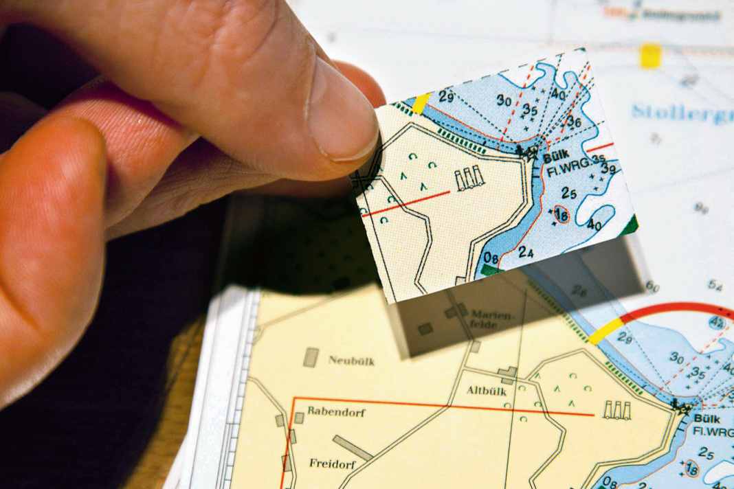
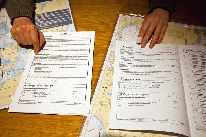
The paper map is updated with the help of corresponding correction sheets provided by the publishers.
1. compare

Firstly, you should download the free update PDF (left) from the relevant map publisher. This usually eliminates the need to purchase a paper correction set (right). Sometimes, however, a provider changes the scale or the section of a map and encloses it with the correction set as a complete replacement sheet. An update via online PDF is then not possible.
2. read

Firstly, study all the instructions in the correction set carefully and assign the notes to the relevant sheets of the card set in question. If there is no cover sheet to stick on for a change, transfer the new information to the card with a waterproof pen. Before doing so, carefully scrape away the information that is no longer current using a razor blade or sharp scalpel.
3. cut out

A correction record usually contains several small cover sheets. Therefore, print the PDF in colour on high-quality paper. If possible, do not use an inkjet printer. Laser prints, on the other hand, are colourfast when wet. The cover sheets on chart paper are included in the purchased version. Cut out the cover sheets exactly along the edges one after the other to avoid confusion.
4. stick on

Work neatly and do not fold the map until the glue has dried. When fitting the cover sheet, coastlines or depth lines help with orientation. With the paper updates, each cover sheet is only available once. If it breaks, the correction set is incomplete. Finally, note the status of the update and who carried it out in the margin of each sheet of a chart set.
Jürgen Albers

The 67-year-old naval architect was Deputy Director of the Federal Bureau of Maritime Casualty Investigation from 2002 to 2023 and has been self-employed again as an expert since retiring. Albers has been sailing on the North Sea and Baltic Sea since his early youth.

