
ARRIVAL
The most important airports in the area are St Martin and Guadeloupe. The former is served by both KLM and Air France, as the island consists of a French and Dutch part. An attractive feature of Air France flights to St Martin is that they are classed as international flights due to the airport in the Dutch part of the island. This means that German travellers do not have to change airports in Paris; they arrive in Paris Charles de Gaulle from Germany and change flights there. This does not apply to the alternative to Guadeloupe, as this is a domestic flight according to the French definition. You therefore have to transfer from Charles de Gaulle Airport to Orly, a transfer right through the heart of Paris that takes around 60 minutes, depending on traffic. KLM flies via Amsterdam, where the problem does not exist.

Until recently, there were still direct flights from Germany to Antigua, but these were cancelled in 2020, so this is currently not an alternative. However, it may be worth asking the agencies whether there is a connection there again, as Antigua is undoubtedly a very attractive port of departure.
CHARTER
There are three main centres of the fleet: The French and Dutch parts of St Martin (Dutch: Sint Maarten), Guadeloupe and Antigua. There are various starting harbours on St. Martin: Marigot Bay in the north-western Dutch part, Anse Marcel in the north or Oyster Point in the east. On Guadeloupe, the charter fleets are concentrated around the large bay of Point-à-Pitre. In Antigua, the bases are located in English Harbour.
WIND & WEATHER
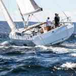
The best time to visit is from the end of the hurricane season at the end of November until April. During this time, a fairly constant trade wind blows from north-east to east, usually at 12 to 25 knots. Until mid-December, the weather is somewhat more unstable than during the rest of the sailing season. There tends to be slightly less wind in April. The direction of the trade winds is favourable for the leewards, to the south there are often rough winds, backwards it is ideally a leeward wind. On the leeward sides of the high, mountainous islands such as Guadeloupe or Dominica, there is often less wind and the wind direction varies more.
Crews in tropical areas must always reckon with heavy but usually short showers or thunderstorms, which then also bring gusts of wind with them.
Most crews obtain weather reports via the usual smartphone apps such as Windy or Windfinder Pro. In the French areas, you are in EU roaming. It can be more expensive off other islands, many crews then use WiFi networks in bars or restaurants.
The hurricane season officially runs from 1 June to 30 November.


NAVIGATION & SEAFARING
If you sail from island to island in the Leewards, you have to complete longer offshore passages in between in the trade winds, which sometimes bring swell and more wind. The wind is weaker and more erratic on the leeward sides, but the harbours and bays are often located there. This is particularly true for St Martin, St Barth, Guadeloupe and Dominica.
Many of the islands are autonomous, which makes constant clearing in and out necessary. This is sometimes convenient, such as in the French part, where there are good computerised PC systems in which most charter vessels can already be found and where the skipper can handle the whole procedure himself. In addition to the boat papers, it is important to always have a crew list and identification papers for the crew with you. For short, one-day stops, it is usually possible to clear in and out with just one visit to the authorities. The computers for such border changes are sometimes only available in marinas (e.g. Marigot Bay St. Martin) or shops (e.g. Deshaies on Guadeloupe). It is best to enquire about the procedure locally, as some offices, including those of officials, close at 5pm or even 4pm.
For the island of Montserrat with its very active volcano, restrictions apply with restricted areas, depending on its activity, which must be enquired about before the trip. There are also some area restrictions imposed by charter companies, for example for the north-eastern part of Antigua. For insurance reasons, some fleet operators do not allow boats to enter its complicated reef-lined bays. This also applies to parts of Barbuda, for whose very shallow, variable waters the nautical charts are also not very reliable.
When approaching harbours and fairways, it must be noted that in the Caribbean the lateral marking system is the reverse of the European one (IALA-B): When entering the fairway from the sea, there are red buoys on the starboard side instead of green ones.
When approaching the anchorages, crews have to rely on "eyeball navigation", i.e. navigating by sight, because of the reef heads. This works according to the colour of the water. Deep water is blue, green or turquoise water is around five to eight metres deep, brown and grey water indicates rocks or coral heads.
Most charter companies prohibit customers from sailing in the dark. You should therefore make sure that you reach the harbour or anchorage by around four or five o'clock at the latest. Exceptions can be made on request, but you are often only allowed to sail outside between the islands. At night, it is usually necessary to keep within a radius of the islands, which in some cases is around ten nautical miles.
HARBOURS & ANCHORAGES
The extensive area between Anguilla in the north and Dominica in the south offers a rich mix of beautiful and safe anchorages and good harbours. On the French islands, the marina infrastructure is denser and more professional, and this also applies to Antigua. On the smaller islands, especially in the west on St Kitts and Nevis, but also Anguilla and Barbuda as well as Dominica, there are often only simple moorings.
Good anchorages are often on the leeward sides of the islands; the north-east sides exposed to the trade winds are often too rough. There is also sometimes swell in the bays on the north and south sides, so crews have to choose carefully depending on the conditions. This is also one of the reasons why there are so many cats in the area: As there is a lot of anchoring, these boats are naturally calmer. There are bays where anchoring is completely free, as well as a whole series where buoy fields are subject to a fee, for example on St Barth, Guadeloupe, Les Saintes and others.
Mooring fees are usually collected in the evening by a marinero in the boat. If the buoys are all occupied, anchoring is also possible next to the buoy fields, although this is expressly forbidden in some national park areas. These are often sandy grounds that offer good holding. Crews must of course avoid reefs for environmental reasons.
LITERATURE & NAUTICAL CHARTS
Territory guide:On many charter yachts you will find the very practical books in the series "The Cruising Guide", there is one volume "Leewards" for the northern part and one for the southern part, 35 euros each (only in English). The French publisher Bloq Maritim offers the volume "Petites Antilles" (French with additional English texts, 39 euros).
Sea chartsThe Leeward Islands package is available from NV-Verlag for 89.90 euros as a set for the whole area. The purchase includes the use of the map set for the NV-Verlag sat nav app. The British publisher Imray offers an over-sailor and individual maps for each major island (23.50 euros each).
TERRITORY CHARACTERISTICS
There are few Caribbean destinations that offer as much variety and diversity as the Leeward Islands. There are the French-influenced islands, which combine a pleasant mix of European infrastructure and Caribbean lifestyle: Good marinas, bakeries with Parisian-style baguettes and croissants, top restaurants with wine fridges, while at the same time the Caribbean way of life. Beach bars, colourful wooden houses and dreamy, palm-fringed beaches. Guadeloupe, the Iles de Saint, St Barth or the French part of St Martin are just such places.
In contrast, there are islands belonging to Great Britain (Anguilla) or the Netherlands (Saba or the Dutch part of the island of Sint Maarten) - with a different national language, less European influence and a more Caribbean flavour. If you want, you can experience three or even four nationalities on one trip and see and feel the colonial past. One of the top destinations in this regard is undoubtedly English Harbour in Antigua. The old naval base around Nelson's Dockyard is one of the most beautiful natural harbours and land spots in the entire Caribbean. Anyone who has ever been there and experienced the legendary steel band and reggae party (always on Sundays) at the top of Shirley Heights will have fallen head over heels for the area. The view from the top over the natural harbour and the bay is also sensational.
The islands also offer other specialities, such as rum production, which is still widespread today, especially on some French islands such as Guadeloupe or Marie Galante, and produces a really good product. The only disadvantage in the area is that the many nationalities also require frequent clearing in and out - something that crews who otherwise only travel in the BVIs are not familiar with.
The two very mountainous islands of Guadeloupe and Dominica, which are covered in dense greenery, are also very special. If you want to go on a tour through tropical forest with waterfalls and steep peaks, this is the right place for you.
Sailing is different to the BVIs: Between the islands, you can sail slightly longer strokes, with the north-east trade wind blowing steadily. The wind direction and location of the islands complement each other quite favourably, often heading south with a rough wind, and with a bit of luck a layline course will be enough to get you back. A good area for crews who want to make a longer trip in the open Atlantic. Most crews that sail here come for 14 days, but even in a fortnight it is not possible to cover the whole area. The charterers either sail southwards from St Martin to Antigua at the most, the others start in the south from Guadeloupe and cover a similar distance. Reason enough to visit the area twice.
